Page
Out
Records
Kerry
Links
| |||||
| Home Page | Starting Out | Online Records | Research Kerry | Resource Links | |
| barony map | |||||
"The townland is the smallest and most ancient of Irish land divisions, and is the goal of all family researchers in identfying the origin of their ancestors. The townland was named at an early period and they usually referred to a very identifiable landmark in the local area such as a mountain, a bog, an oak forest a village, a fort or a church. The townland became standardised as a basic division in the 17 th century surveys by people with little knowledge of the Irish language. As a consequence many place names were either lost or had their meaning or construction altered." Brian Mitchell, Inner City Trust 1989.
It is very hard to find a good detailed map of Kerry, nevermind online, especially when what you want to know most is where a tiny townland is located. Recognizing this lack of unavailable important information, we have tried to fulfill that need on the Kerry site.
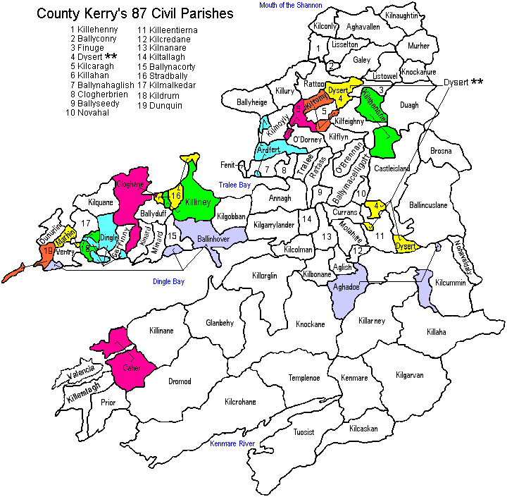
Below is a list and map of all the Civil Parishes of County Kerry. Some parishes that are in parts have been color coded on the map for easier identification. Click on a Civil Parish name from the list to see a more detailed map and list of the townlands contained within that parish.
Towns/Townlands: "One of the confusing things about Irish government is that the "towns" for the most part really had no legal status. That is, no government function. They were just built-up areas. Therefore, you can't really look for "Ballylongford Town" on the Griffiths Valuation and find anything, (nor will you find them on Government Ordance Survey maps which our townland maps are based on - Waterlilys). It might be as many as a half dozen townlands which contain the areas which comprise the "Town of Ballylongford" or Castleisland or whatever." Ray Marshall. Therefore towns will be listed without acres or map numbers; instead you will see DNA = Does Not Apply.
Note: The townland lists are according to the "General Alphabetical Index to the Townlands of Ireland" 1851, but some Townlands listed are not on the map information we have available which are modeled after the Inner City Trust Maps, based on the Ordnance Survey completed in 1846. Over the years there have been changes such as consolidation of townlands or new townlands taken from parts of other townlands that may account for some of the differences, and some may be islands not pictured on these maps. Three parishes in particular (66 Knockane, 49 Killarney, and 82 Templenoe) with shared borders, all have missing townlands on the maps.
This has been a huge project and I couldn't have done it alone. Many thanks to Bridget Smith for providing the map data, to Mary Shankle for providing the basis for the map below, to John Willoughby, Peter Schermerhorn for their assistance, and to Ann Hammer for all her invaluable help in creating these maps with me ~ Waterlilys.
The map on this page is labeled with the civil parish names, along with lists of the civil parishes in alphabetical order to the sides. Also check another map we have for you, an overlay showing the Baronies of County Kerry in relation to the civil parishes.
| * Alternative Spellings (by no means complete) | |
| Ballyheige = Ballyheigh Caher = Cahir Castleisland = Castle Island Glanbehy = Glanbeigh, Glenbay | Kilcaskan = Kilcuskan Kilmalkedar = Kilmelkadar, Kilmalchedar Ratoo = Raithtoug Valencia = Valentia |
| ** There are two separate parishes named Dysert: Dysert (North or Dysert-Listowel) Dysert (South or Dysert-Trughanacmy) | |