
Page
Out
Records
Kerry
Links
|
||||
| Home Page |
Starting Out |
Online Records |
Research Kerry |
Resource Links |
| Civil Parishes | ||||
Many thanks to Sean Ruad for this data from the IreAtlas Townland database
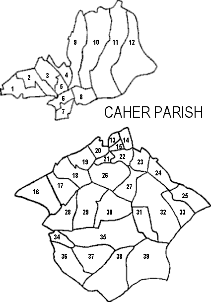
| Caher Civil Parish, Cahersiveen PLU,
Iveragh Barony, Munster Province |
||
|---|---|---|
| Towns/Townlands | Acres | Map # |
| Aghatubrid | 992 | 38 |
| Ballycarbery East | 235 | 8 |
| Ballycarbery South | 159 | 7 |
| Ballycarbery West | 184 | 6 |
| Beginish | 217 | ** |
| Boherboy | 148 | 14 |
| Boola | 127 | 34 |
| CAHERSIVEEN T. | DNA | * |
| Cahersiveen | 255 | 19 |
| Canburrin | 1,293 | 32 |
| Carhan Lower | 200 | 20 |
| Carhan Upper | 553 | 26 |
| Castlequin | 1,192 | 11 |
| Cloghanecarhan | 1,039 | 39 |
| Cloghanelinaghan | 1,169 | 12 |
| Derreen | 592 | 36 |
| Emlagh | 162 | 4 |
| Foughil Island | 15 | ** |
| Garranearagh | 414 | 17 |
| Garranebane | 506 | 18 |
| Gurteen | 343 | 27 |
| Hillgrove | 99 | 21 |
| Inchiclogh | 227 | 22 |
| Inchimacteige | 252 | 23 |
| Kilcoman | 505 | 37 |
| Killelan East | 353 | 2 |
| Killelan West | 324 | 1 |
| Killoe | 612 | 30 |
| Killogrone | 340 | 31 |
| Kimego East | 1,019 | 10 |
| Kimego West | 695 | 9 |
| Knockaunrory | 78 | 15 |
| Laharan North | 318 | 3 |
| Laharan South | 1,387 | 35 |
| Lamb Island | 2 | ** |
| Letter | 683 | 29 |
| Moneyduff | 54 | 13 |
| Mountluke | 117 | 5 |
| Oghermong | 496 | 28 |
| Reenard | 647 | 16 |
| Rehill | 428 | 25 |
| Tooreenmore | 371 | 33 |
| Turnamucka | 278 | 24 |
* DNA = Does Not Apply. Read why.
** Indicates an island, which is not shown on these maps.
Note: Caher Parish is in two parts that do not touch; they are across the Valencia River from each other.