
Page
Out
Records
Kerry
Links
|
||||
| Home Page |
Starting Out |
Online Records |
Research Kerry |
Resource Links |
| Civil Parishes | ||||
Many thanks to Sean Ruad for this data from the IreAtlas Townland Database
| Aghadoe Civil Parish, Killarney PLU, Munster Province | ||||
|---|---|---|---|---|
| Townland | AKA | Acres | Barony | Map# |
| Aghacurreen | 412 | Magunihy | 8 | |
| Aghalee More | 185 | Magunihy | 4 | |
| Annaghily More | 1,107 | Magunihy | 44 | |
| Ards | 211 | Magunihy | 13 | |
| Ballinlough | 109 | Dunkerron North | 39 | |
| Ballydowny | 91 | Magunihy | 35 | |
| Barraduff | 408 | Magunihy | 49 | |
| Brown Island | Rabbit Island | 12 | Magunihy | ** |
| Bunrower | 197 | Magunihy | * | |
| Caher | 178 | Magunihy | 19 | |
| Cahernane | 75 | Magunihy | * | |
| Cleeny | 89 | Magunihy | 34 | |
| Coolcorcoran | 289 | Magunihy | 21 | |
| Coolgarriv | 224 | Magunihy | 20 | |
| Cools | 375 | Magunihy | 52 | |
| Crohane | 466 | Magunihy | 6 | |
| Cullinagh | 598 | Dunkerron North | 42 | |
| Curragh | 305 | Magunihy | 7 | |
| Dooneen | 262 | Magunihy | 22 | |
| Dromdoohig More | 367 | Magunihy | 1 | |
| Dromin | 239 | Magunihy | 14 | |
| Farranaspig | 70 | Magunihy | 32 | |
| Fossa | 177 | Magunihy | 29 | |
| Gortacollopa | 229 | Magunihy | 12 | |
| Gortadirra | 1,527 | Dunkerron North | 40 | |
| Gortaree | 137 | Magunihy | 16 | |
| Gortnacarriga | 258 | Magunihy | 3 | |
| Gortreagh | 98 | Magunihy | 26 | |
| Gortroe | 382 | Magunihy | 31 | |
| Greenagh | 299 | Magunihy | 24 | |
| Groin | 67 | Magunihy | 33 | |
| Headfort | 385 | Magunihy | 53 | |
| Innisfallen | 21 | Magunihy | ** | |
| Kilbreanbeg | 198 | Magunihy | 23 | |
| Killalee | 116 | Magunihy | 25 | |
| Killeen | 367 | Magunihy | 2 | |
| Knockanarroor | 541 | Magunihy | 48 | |
| Knockasarnet | 298 | Magunihy | 9 | |
| Knockeenduff | 367 | Magunihy | 10 | |
| Knockeennagowan | 345 | Magunihy | 50 | |
| Knockreer | 436 | Magunihy | 36 | |
| Knockysheehan | 493 | Magunihy | 46 | |
| Knoppoge | 329 | Magunihy | 15 | |
| Lackabane | 338 | Magunihy | 30 | |
| Lamb Island | 1 | Magunihy | ** | |
| Leamyglissane | 189 | Magunihy | 43 | |
| Lisbabe | 554 | Magunihy | 47 | |
| Lismongane | 156 | Magunihy | 27 | |
| Maulagh | 164 | Magunihy | 28 | |
| Nunstown | 170 | Magunihy | 18 | |
| Pallis | 171 | Magunihy | 11 | |
| Parkavonear | 124 | Magunihy | 17 | |
| Rabbit Island | Brown Island | 12 | Magunihy | ** |
| Raheen | 234 | Magunihy | 45 | |
| Rossacroo | 229 | Magunihy | 54 | |
| Scarteen | 175 | Magunihy | 5 | |
| Shronedarragh | 482 | Magunihy | 51 | |
| Tomies East | 136 | Dunkerron North | 38 | |
| Tomies West | 252 | Dunkerron North | 37 | |
| Tomies Wood | 267 | Dunkerron North | 41 | |
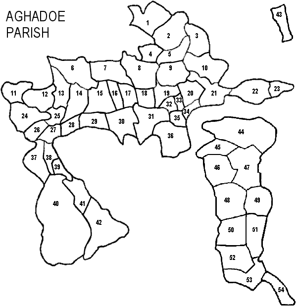
*Bunrower and Cahernane are both townlands in Aghadoe according to: "General Alphabetical Index to the Townlands of Ireland" 1851, but are not on the map information we have available which are modeled after the Inner City Trust Maps (based on the Ordnance Survey 1846).
**Indicates an island, which are not included on these maps.
Note: Three separate parts of Aghadoe Parish are not located next to each other; other parishes come in between them. Some of the townlands are not even in the same barony. The distance between the segments shown here are not accurate. Consult the map showing all the civil parishes for a better view of these distances.