
Page
Out
Records
Kerry
Links
| ||||
|
| ||||
| Home Page |
Starting Out | Online Records |
Research
Kerry |
Resource Links |
| Civil Parishes | ||||
Note: This map is not to be considered accurate. The Innercity Trust map that was used for the basis of this map was flawed and extremely hard to read. The smallest of the townlands were numbered rather than name labeled on the Innercity Trust maps; the key to the numbered areas on the original map is what was illegible. We have done our best to approximate where these townlands are located using contemporary borderless maps and the acreage data from the book "General Alphabetical Index to the Townlands of Ireland" 1851. Due to changes in townland borders over the years not all townland locations have been identified. Please consider the locations of the smallest of townlands as our best guess as to thier actual locations.
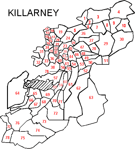
| Killarney, Magunihy Barony Killarney PLU, Munster Province |
||
|---|---|---|
| Townland | Acres | Map# |
| Ardagh | 145 | 41 |
| Ardaneanig | 232 | 28 |
| Ardnamweely | 45 | 20 |
| Ardshanavooly | 104 | 17 |
| Avenue | 67 | 21 |
| Ballahacommane | 1,128 | 29 |
| Ballycasheen | 353 | 23 |
| Ballydribbeen | 80 | 12 |
| Ballydrisheen | 59 | 43 |
| Ballyspillane | 29 | 25 |
| Brickeen Island | 19 | |
| Bunrower | 197 | 33 |
| Cahernane | 188 | 36 |
| Carrigafreaghane | 79 | 14 |
| Carrigeencullia | 1,485 | 30 |
| Castlelough | 125 | 40 |
| Clash | 225 | 48 |
| Clasheen | 244 | 49 |
| Cloghereen Lower | 256 | 60 |
| Cloghereen Upper | 270 | 70 |
| Cloghfune | 242 | 67 |
| Coolcaslagh | 455 | 27 |
| Coolclogher | 119 | 39 |
| Coolies | 2,254 | 62 |
| Coollegrean | 56 | 56 |
| Cores | 1,434 | 73 |
| Cow Island | 2 | |
| Crinnagh | 571 | 68 |
| Deer Park | 420 | 19 |
| Demesne | 174 | 34 |
| Derreen | 70 | 11 |
| Derrycunihy | 524 | 77 |
| Dinish Island | 34 | |
| Dromhale | 103 | 22 |
| Dromhumper | 158 | 45 |
| Dromickbane | 202 | 52 |
| Dromyrourk | 266 | 59 |
| Faghbane | 109 | 46 |
| Faghcullia | 358 | 53 |
| Ferta | 938 | 72 |
| Glena | 2,062 | 64 |
| Gortagullane | 870 | 61 |
| Gortahoonig | 115 | 55 |
| Gortderraree | 389 | 66 |
| Gortdromakiery | 3,022 | 63 |
| Gortracussane | 408 | 65 |
| Gortroe | 1,353 | 76 |
| Inch | 77 | 13 |
| Incheens | 580 | 78 |
| KILLARNEY T. | DNA | ** |
| Kilbrean More | 301 | 1 |
| Kilcoolaght | 43 | 18 |
| Killarney | 41 | 16 |
| Killegy Lower | 146 | 79 |
| Killegy Upper | 303 | 71 |
| Knockaninane East | 937 | 4 |
| Knockaninane West | 777 | 3 |
| Knockeanagh | 469 | 7 |
| Knockmanagh | 261 | 8 |
| Knocknahoe | 468 | 9 |
| Knocknaskeha | 418 | 10 |
| Lissyviggeen | 552 | 47 |
| Listymurragh | 63 | 15 |
| Minish | 522 | 50 |
| Monearmore | 21 | 42 |
| Moyeightragh | 70 | * |
| Muckross | 759 | 57 |
| Oldforge | 146 | 51 |
| Park | 353 | 24 |
| Poulagower | 1,314 | 74 |
| Poulnamuck | 81 | 38 |
| Radrinagh | 106 | 6 |
| Reen | 283 | 31 |
| Ross Island | 158 | 32 |
| Rossnahowgarry | 130 | 58 |
| Rough Island | 1 | |
| Scartlea | 126 | 54 |
| Scrahane | 96 | 35 |
| Sheheree | 221 | 44 |
| Teernaboul | 635 | 26 |
| Torc | 362 | 69 |
| Tullig | 319 | 5 |
| Tullorum | 97 | 2 |
| Ullauns | 1,587 | 75 |
| Woodlawn | 67 | 37 |
* indicates a townland in Killarney according to: "General Alphabetical Index to the Townlands of Ireland" 1851, but is not on the map information we have available which are modeled after the Inner City Trust Maps, based on the Ordnance Survey completed in 1846.
** DNA = Does Not Apply. Read why.