
Page
Out
Records
Kerry
Links
| ||||
|
| ||||
| Home Page |
Starting Out | Online Records |
Research
Kerry |
Resource Links |
| Civil Parishes | ||||
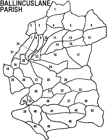
| Ballincuslane Parish, Tralee PLU Trughanacmy Barony, Munster Province |
||
|---|---|---|
| Townland | Acres | Map # |
| Adraval | 206 | 35 |
| Ballahantouragh | 81 | 21 |
| Ballinard | 1,048 | 11 |
| Ballynahallia | 338 | 19 |
| Ballynahulla | 1,510 | 43 |
| Ballyplimoth | 232 | 20 |
| Barna | 1,571 | 46 |
| Breahig | 804 | 26 |
| Carker | 938 | 39 |
| Coollegrean | 1,246 | 13 |
| Coom | 1,799 | 16 |
| Cordal East | 1,886 | 28 |
| Cordal West | 1,219 | 27 |
| Craggaunoonia | 99 | * |
| Derreen | 1,033 | 36 |
| Fieries | 407 | 18 |
| Glanawaddra | 1,415 | 33 |
| Glanlarehan | 549 | 8 |
| Glanowen | 1,718 | 29 |
| Gortacappul | 285 | 34 |
| Gortglass | 829 | 25 |
| Kilberehert | 63 | 22 |
| Kilcusnaun | 739 | 7 |
| Kilmurry | 398 | 23 |
| Kilquane | 1,048 | 24 |
| Knockachur | 721 | 3 |
| Knockatee | 668 | 14 |
| Knockauncurragh | 1,705 | 17 |
| Knockdown | 658 | 32 |
| Knockeennahone | 829 | 41 |
| Knocknaboul | 1,274 | 38 |
| Knocknadarriv | 1,517 | 5 |
| Knockreagh | 448 | 44 |
| Knockrower East | 1,086 | 45 |
| Knockrower West | 799 | 40 |
| Knockyeala | 848 | 37 |
| Lackabane | 591 | 12 |
| Lackanoneen | 466 | 2 |
| Lackbrooder | 1,118 | 1 |
| Leaha | 324 | 31 |
| Leamydoody | 317 | 9 |
| Lyre | 561 | 10 |
| Mullen | 833 | 30 |
| Reacaslagh | 1,224 | 6 |
| Tooreenagowan | 796 | 4 |
| Tooreengarriv | 713 | 42 |
| Tooreennascarty | 755 | 15 |
*Craggaunoonia is a townland in Ballincuslane according to: "General Alphabetical Index to the Townlands of Ireland "1851, but it is not on the map information we have available which are modeled after the Inner City Trust Maps (based on the Ordnance Survey 1846).