Page
Out
Records
Kerry
Links
 |
||||
| Home Page |
Starting Out |
Online Records |
Research Kerry |
Resource Links |
| Civil Parish List | ||||

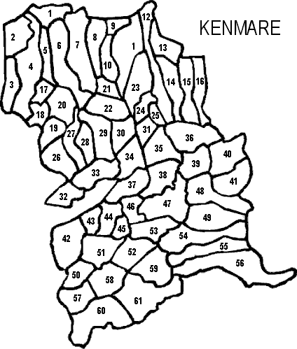
| Kenmare Civil Parish, Kenmare PLU, Glanarought Barony, Munster Province |
||
|---|---|---|
| Townland | Acres | Map # |
| Ballygriffin | 418 | 51 |
| Barraduff | 341 | 57 |
| Caher East | 483 | 36 |
| Caher West | 234 | 35 |
| Cappagh | 383 | 55 |
| Cappamore | 636 | 3 |
| Carhoomeengar East | 223 | 18 |
| Carhoomeengar West | 249 | 17 |
| Carrignahihilan | 119 | 45 |
| Cooragweanish | 238 | 16 |
| Carrig East | * | 2 |
| Cummeenboy | 765 | 11 |
| Currabeg | 452 | 47 |
| Derreenacahill | 447 | 12 |
| Derrygarriv | 365 | 58 |
| Derrylahan | 560 | 48 |
| Derrynacaheragh | 684 | 60 |
| Derrynacoulagh | 730 | 61 |
| Doughill | 423 | 49 |
| Dromanassig | 466 | 59 |
| Dromatouk | 485 | 38 |
| Dromcahan East | 303 | 30 |
| Dromcahan West | 366 | 29 |
| Dromneavane | 330 | 26 |
| Fustane Lower | 471 | 14 |
| Fustane Upper | 236 | 13 |
| Gearhadiveen | 403 | 53 |
| Gortagass | 357 | 34 |
| Gortalassa | 103 | 25 |
| Gortalinny North | 395 | 37 |
| Gortalinny South | 258 | 46 |
| Gortlahard | 784 | 56 |
| Gortnaboul Lower | 203 | 10 |
| Gortnaboul Upper | 126 | 9 |
| Gortnacurra | 355 | 15 |
| Gortnadullagh | 205 | 44 |
| Gortrooskagh | 323 | 52 |
| Gowlane | 651 | 7 |
| Inchimore | 311 | 22 |
| Istalea Lower | 151 | 21 |
| Istalea Upper | 349 | 8 |
| KENMARE T. | DNA | ** |
| Kenmare | 268 | 32 |
| Kenmare Old | 253 | 43 |
| Kilcurrane East | 665 | 6 |
| Kilcurrane West | 160 | 5 |
| Kilgortaree | 412 | 39 |
| Kilkeana | 645 | 4 |
| Killowen | 301 | 33 |
| Kilmurry | 298 | 27 |
| Kilpatrick | 148 | 31 |
| Lackaroe | 608 | 54 |
| Letter Lower | 367 | 40 |
| Letter Upper | 407 | 41 |
| Lissaniska | 231 | 28 |
| Lissyclearig Lower | 196 | 19 |
| Lissyclearig Upper | 258 | 20 |
| Mucksna | 705 | 42 |
| Rossboy | 173 | 24 |
| Rusheens | 315 | 50 |
| Tooreenbreanla | 272 | 1 |
| Tullig | 391 | 23 |
* Carrig East is on the Innertrust Townland list for this parish, but it is not inculded in "Aphabetical Index to the Townlands of Ireland" 1851, which is where the data for the acres of the townlands is located.
** DNA = Does Not Apply. Read why.