
Page
Out
Records
Kerry
Links
| ||||
|
| ||||
| Home Page |
Starting Out | Online Records |
Research
Kerry |
Resource Links |
| Civil Parishes | ||||
Many thanks to Sean Ruad for this data from the IreAtlas Townland Database
| Ratass, Tralee PLU,
Trughanacmy Barony, Munster Province |
||
|---|---|---|
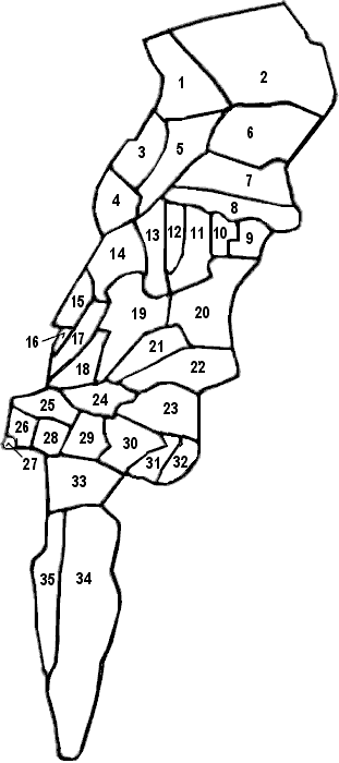
| Townlands | Acres | Map # |
| Ballingowan | 229 | 23 |
| Ballinorig East | 329 | 20 |
| Ballinorig South | 275 | 22 |
| Ballinorig West | 132 | 21 |
| Ballintobeenig | 377 | 6 |
| Ballinvosherig East | 82 | 9 |
| Ballinvosherig West | 84 | 10 |
| Ballybeggan | 254 | 19 |
| Ballymullen | 29 | 27 |
| Ballynabrennagh Lower | 221 | 8 |
| Ballynabrennagh Upper | 242 | 7 |
| Caherleheen | 826 | 34 |
| Camp | 160 | 33 |
| Clash East | 170 | 18 |
| Clash West | 64 | 16 |
| Cloon Beg | 71 | 26 |
| Cloon More | 99 | 25 |
| Cloonalour | 144 | ** |
| Curraghleha East | 56 | 32 |
| Curraghleha West | 74 | 31 |
| Dromthacker | 242 | 14 |
| Killierisk | 48 | 28 |
| Knockawaddra East | 111 | 11 |
| Knockawaddra Middle | 88 | 12 |
| Knockawaddra West | 174 | 13 |
| Laharan | 142 | 4 |
| Leath East | 728 | 2 |
| Leath West | 281 | 1 |
| Lismore | 267 | 5 |
| Lissatanvally | 153 | 3 |
| Manor East | 161 | 30 |
| Manor West | 154 | 29 |
| Muing East | 52 | 17 |
| Muing West | 78 | 15 |
| Ratass | 128 | 24 |
| Skahanagh | 239 | 35 |
| TRALEE T. | DNA | * |
* DNA = Does Not Apply. Read why.
** Cloonalour townland is in Ratass civil parish according to "General Alphabetical Index to the Townlands of Ireland" - 1851, but it is not located in the map information we have available which is modeled after the Inner City Trust Maps (based on the Ordnance Survey 1846).