Page
Out
Records
Kerry
Links
|
|||||
| Home Page |
Starting Out |
Online Records |
Research Kerry |
Resource Links |
|
| Civil Parishes | |||||
BALLYMACELLIGOTT, a parish in the barony of Trughenackmy, 4¾ miles east-south-east of Tralee, Co. Kerry, Munster. Length, 3½ miles; breadth, 3; area, 14,018 acres. Pop., in 1831, 3,535; in 1841; 4,058. Houses 660. About one-third of the area is bog or coarse upland pasture; and the remainder is variously third-rate, second-rate, and first-rate land. Two small river systems give the western and the eastern divisions respectively a westerly and a south-westerly exposure. The road from Castle-Island to Tralee traverses the interior; and, while within the parochial limits, passes along a beautiful and generally luxuriant valley, and is overlooked by the mansions of Rattany, Arbela, and Chute-Hall. This parish is a rectory in the dio. of Ardfert and Aghadoe. Tithe composition, L 336 18s. 5d.; glebe, L 15. The rectories of Ballymacelligott, Currens, and Nohoval-Kerry constitute the benefice of Ballymacelligott. Length and breadth, each 5 miles. Gross income, L 496 11s. 4d.; nett, L 429 14s. 6d. Patron, the Crosbie family of Ardfert Abbey. The church was built in 1824, by means of a loan of L 646 3s. 1d. from the late Board of First Fruits. Sittings 250; attendance, 100 in winter and 180 in summer. Two Roman Catholic chapels have an attendance of 900; and are served by one officiate. A Methodist meeting-house has an attendance of 50. In 1834, the Protestants of the parish amounted to 450, and the Roman Catholics to 3,656; the Protestants of the union to 465, and the Roman Catholics to 4,057; and 6 daily school - 5 of which were in the parish, and one of these aided with L 5 5s. a-year from the incumbent, and L 14 from the Incorporated Society - had on their books 179 boys and 101 girls. (The Parlimentary Gazetteer of Ireland, 1844. p. 179. FHL 6020358-82, transcription shared by Nancy Bussey)
Many thanks to Sean Ruad for this data from the IreAtlas Townland Database
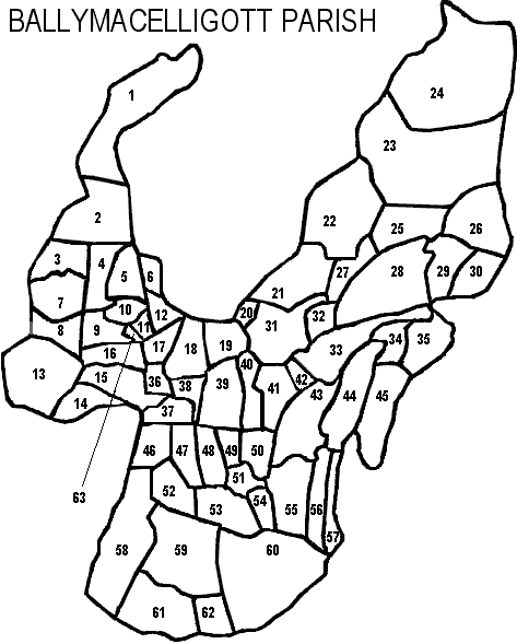
| Ballymacelligott Parish, Tralee PLU Trughanacmy Barony, Munster Province |
||
|---|---|---|
| Townland | Acres | Map # |
| Ahane | 178 | 53 |
| Arabela | 154 | 48 |
| Ash-hill | 345 | 58 |
| Ballineedora | 113 | 32 |
| Ballinknock | 112 | 17 |
| Ballyaukeen | 299 | 2 |
| Ballybeg | 76 | 36 |
| Ballybrannagh | 143 | 19 |
| Ballydwyer Middle | 136 | 40 |
| Ballydwyer West | 179 | 39 |
| Ballydwyer East | 184 | 41 |
| Ballyfinoge | 179 | 18 |
| Ballymacelligott | 97 | 47 |
| Ballynahinch | 80 | 10 |
| Barrakilla | 201 | 3 |
| Bealagrellagh | 72 | * |
| Caherbreagh | 387 | 13 |
| Cahercullenagh Lower | 283 | 21 |
| Cahercullenagh Upper | 520 | 22 |
| Cahermore | 89 | 51 |
| Carrignafeela | 81 | 12 |
| Clashatlea | 335 | 61 |
| Cloghavoola | 130 | 27 |
| Clogher | 41 | 42 |
| Clogherclemin | 204 | 9 |
| Cloghermore | 62 | 37 |
| Coolnadead | 124 | 46 |
| Curraghmacdonagh | 25 | 14 |
| Doonimlaghbeg | 158 | 52 |
| Flemby | 518 | 59 |
| Garraun Beg | 87 | 34 |
| Garraun More | 232 | 35 |
| Glanageenty | 421 | 28 |
| Gortagullane | 68 | 49 |
| Gortatlea | 699 | 60 |
| Gortnaleaha | 107 | 6 |
| Gortshanvally | 82 | 38 |
| Kilbane | 291 | 33 |
| Kilkerry | 101 | 50 |
| Kilquane | 133 | 16 |
| Knockatarriv | 293 | 26 |
| Knockavinnane | 136 | 15 |
| Kylebeg | 132 | 8 |
| Lissooleen | 28 | 63 |
| Loughnacappagh | 36 | * |
| Magh East | 142 | 57 |
| Magh West | 196 | 56 |
| Maglass East | 235 | 45 |
| Maglass West | 291 | 44 |
| Martara | 87 | 54 |
| Mountnicholas | 108 | 62 |
| Muingnaminnane | 1,019 | 23 |
| Muingnatee | 230 | 25 |
| Mweelinroe | 38 | 20 |
| Potaley | 17 | 11 |
| Rathanny | 257 | 31 |
| Reanagowan | 1,093 | 24 |
| Rockfield | 305 | 43 |
| Shanavally | 269 | 55 |
| Tonreagh Lower | 157 | 5 |
| Tonreagh Upper | 137 | 4 |
| Tooreen | 170 | 29 |
| Tooreennastooka | 136 | 30 |
| Tullygarran | 163 | 7 |
| Tursillagh | 580 | 1 |
* Bealagrellagh and Loughnacappagh are townlands in Kerry according to: "General Alphabetical Index to the Townlands of Ireland" 1851, but it is not on the map information we have available which are modeled after the Inner City Trust Maps (based on the Ordnance Survey 1846).