
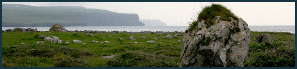
County Clare-IGP © Jeanne Foley Dwyer | Terms of Use

According to the Clare County Library, County Clare was named for the Irish word clar, meaning "plank" or "board" used for crossing the River Fergus outside Ennis at present-day Clarecastle, not for the de Clare family as is commonly believed.
Send in your photos
If you’re lucky enough to get back home to Clare, you’re lucky enough! Share your luck with your photos, and we’ll feature them here.
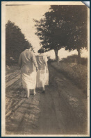
Margaret and Mae,
by Jeanne Foley Dwyer
1. Ennis
2. Shannon
3. Kilrush
4. Newmarket-on-Fergus
5. Kilkee
6. Sixmilebridge
7. Killaloe
8. Ennistymon (Ennistimon)
9. Lisdoonvarna
10. Scariff (Scarriff)

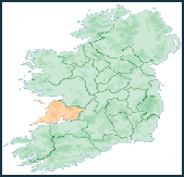
Bodies of water define much of the physical boundaries of Clare. To the southeast is the River Shannon, Ireland's longest river, and to the south is the Shannon Estuary. The border to the northeast is defined by Lough Derg which is the third largest lake on Ireland. To the west is the Atlantic Ocean, and to the north is Galway Bay.
County Clare contains The Burren, a unique karst region, which contains rare flowers and fauna. At the western edge of The Burren, facing the Atlantic Ocean, are the Cliffs of Moher. The highest point in County Clare is Moylussa, 532m, in the Slieve Bernagh range in the east of the county. (from www.wikipedia.com)
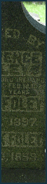
Grave Inscriptions
(more at www.clarelibrary.ie)
Major Towns
(more at www.clarelibrary.ie)
