|
When attempting to research your Irish ancestors,
you should first understand the system of Irish land divisions.
The administrative divisions in Ireland consisted of
a variety of land
units in descending order of size: Province, County, Barony, Parish and
Townland.
BARONY
Originally the landholding of a feudal baron, the
barony is now an obsolete administrative unit that is mid-way in size
between a county and a parish. The system of bringing Irish local
kingdoms into the feudal
system of baronies began in the medieval period but did not extend to
the whole of Ulster until the early 17th century.
Large baronies were later subdivided until there
were 58 baronies in the area that comprises the present day Northern
Ireland.
Baronies of County Wicklow
- Lower Talbotstown
- Upper Talbotstown
- Rathdown
- Ballinacor North
- Ballinacor South
- Shillelagh
- Newcastle
- Arklow
COUNTY
A territorial unit equivalent to the English shire,
it was created
by the English administration in Ireland as the major subdivision of an
Irish province and dates from the 13th to the 17th century. The
counties as they are today were planned in 1584 but many existed long
before this date.
Antrim and Down had been counties from the 13th or
14th centuries but their modern boundaries were not settled until 1605,
while the modern boundary and the new county name of Londonderry did
not come into existence until 1613 although it had existed from
Anglo-Norman
times with different boundaries and under the name of Coleraine.
PARISH
An ecclesiastical unit of territory that came into
existence in
Ireland in its present form in the 12th and 13th centuries and was
continued by the Established Church of Ireland after the Reformation.
It was then adopted as a civil administrative area but over time the
boundaries of some civil and ecclesiastical parishes came to vary from
each other. Roman Catholic parishes, for example, when re-instated,
were often redrawn to suit the needs of their parishioners. Because
civil parishes may extend across rivers that were often used to
delineate the boundaries of counties and baronies, civil parishes can
be in more than one county and in more than one barony.
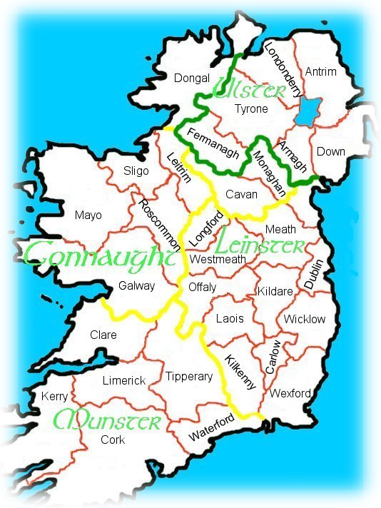
PROVINCE
This is the earliest and largest administrative
division in Ireland dating back into prehistory and early historic
times. There were originally five Provinces in the island of Ireland
with provincial
'overkings' who were supported by the kings of the smaller local
kingdoms within them. However, by the 17th century this had been
reduced to the four modern Provinces of Ulster, Connaught, Leinster and
Munster.
Present day Northern Ireland comprises six of the
nine counties established in the Province of Ulster - the Ulster
counties of Cavan,
Donegal and Monaghan lie in the Republic of Ireland.
|