History:
Originally
part of the ancient kingdom of Bréifne, this inland county contains the
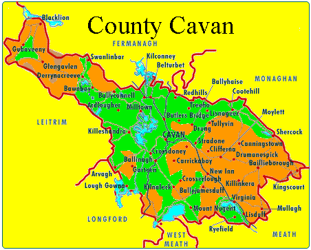
towns of Arvagh, Bailieborough,Ballinagh, Ballyconnell,
Ballyhaise, Ballyjamesduff, Ballymagauran, Bawnboy, Belturbet,
Blacklion, Butlersbridge, Canningstown, Cavan, Cootehill, Crossdoney,
Dowra,
Drumcarban, Kilcogy, Killeshandra, Kilnaleck, Kingscourt, Lough Gowna,
Mullagh, Mountnugent, Redhill, Shercock, Stradone, Swanlinbar and
Virginia.
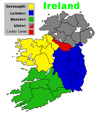
It is the
southern-most province of traditional Ulster, and measures
approximately 47 miles long by 23 miles across. It is bounded to the
west by Leitrim, to the north by Fermanagh and Monaghan, to the east by
the latter county and Louth, and to the south by Longword, West Meath
and East Meath.
This part of Bréifne was ruled by the O'Reillys, from the town of
Cavan, and as a result was called Bréifne O'Reilly. The other part of
Bréifne, County Leitrim, was known as Bréifne O'Rourke, for the ruling
clan there. In addition to the O'Reillys, other prominent families in
Cavan are Brady, O'Mulleady, McGovern, Sheridan, O'Farrelly, McKiernan,
O'Curry, O'Clery, McIlduff, and of course, McGowan (Smith or Smyth).
The Celtic origin of Cavan is "cabhán," meaning "hollow" or "little
hill", an apt description of the countryside, especially towards the
northwest, where the landscape is covered by drumlins -- oval clay
hills of glacial origin between 80 to 100 feet high. In between these
rolling hills, the valleys are poorly drained, with extensive bogs,
swamps and lakes. This corrogated geography means that visibility is
frequently limited, often no more than a few hundred yards, giving the
countryside an intimate feel. The Cuilcagh mountain range contain the
highest point, Cuilcagh, at 665 metres (2,182 feet).
This geography also helped the O'Reilly Clan retain control in County
Cavan even after the Norman arrival in Ireland in 1169. The difficulty
of traversing the Cavan terrain, with its many thick forests, hidden
valleys, watery bogs and lakes, combined with the skill of the O'Reilly
cavalry, and the intractability of the local residents, kept the Norman
invaders successfully at bay for several centuries. In fact, the
O'Reillys maintained their independence from later English rule until
the rebellions of the early 1600s.
When the Catholic Confederacy was finally defeated by Cromwell in 1649,
the Catholic lands in Cavan were confiscated and given to English
soldiers and others loyal to the British crown. In the midst of these
battles, the famine swept through County Cavan. In 1841, the population
in Cavan was 243,000, and by 1851 it had dropped to 174,000. With
emigration, famine deaths, and occupation by the British, the
population of Cavan would drop to a low of 55,000. However, the census
of 1861 shows that it was still overwhelmingly Catholic (81 percent)
with the remaining population divided between Presbyterians and members
of the Church of Ireland. (Above maps and text courtesy of Scott
Michaud - Mazhude@hotmail.com)
You can still see Norman influence in places like of Clogh
Oughter castle. The famous General Eoghan Rua O Neill (Red Owen), died
here in 1649.
Geography
Cavan is
known as 'The Lakeland County' and is reputed to contain 365 lakes. At
18.8 km2 (7.3 sq mi), Lough Sheelin is the county's largest lake; it is
situated in the south of the county and forms a three way border on its
waters between counties Meath, Westmeath and Cavan. A large complex of
lakes form in the north and west of Cavan into designated Specially
Protected Areas (SPA); an example is Lough Oughter. Other important
wildlife protected lakes such as Lough Gowna and Lough Ramor are in the
south and east of the county. Cavan has a mainly hilly (drumlin)
landscape and contains just under 7,000 hectares (17,000 acres) of
forested area, 3.6% of Cavan's total land area. The county contains
forests such as Bellamont Forest near Cootehill, Killykeen Forest Park
at Lough Oughter (a Coillte state forest concern), Dún na Rí Forest
Park and the Burren Forest.
Cavan is also the source of many rivers. Shannon Pot on the slopes of
Cuilcagh is the source of the River Shannon, the longest river in
Ireland at 386 km (240 mi). The River Erne is a major river which rises
from Beaghy Lough, two miles (3 km) south of Stradone in Cavan and
flows for 120 km (75 mi) to Lough Erne. Other rivers in the county
include the Blackwater River, which rises near Bailieborough and flows
through Lough Ramor, joining the River Boyne at Navan; the Dee which
springs near Bailieborough; the River Annalee which flows from Lough
Sillan and joins the Erne; and the Cladagh river which rises from
Cuilcagh and flows into Fermanagh. The Glyde and the Owenroe also
source in Cavan.Cavan
was
once called East Brefnie or Brefnie O'Reilly. It was part of the
province of Connaught, but in 1584 became part of Ulster.