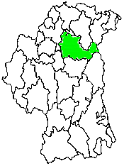
Kilmore Civil Parish
County Armagh, Northern Ireland
| Barony | Oneilland West, Orior Lower |
| Poor Law Union | Armagh, Banbridge |
| Catholic Diocese | Armagh |
| Catholic Parish | Kilmore (Mullavilly) |
| Presbyterian Congregations | Ahorey, Keady 1st/The Temple, Richill |
Search the IGP County Armagh website
|
KILMORE, a parish, partly in
the barony of LOWER ORIOR, but chiefly in that of O'NEILLAND WEST,
county of ARMAGH, and province of ULSTER, on the road from Armagh to
Belfast; containing, with the post-town of Richhill (which is described
under its own head), 14,037 inhabitants. This place, anciently called
Kilmore-Aed-hain, derived that name from the foundation of a church in
the territory of Huadneth, by St. Mochtee, the founder of Louth, by whom
it was dedicated to St. Aedan. |
|
Do you have a description of this civil parish or a picture? If you send it/them, I will put it/them in this space. |
Townlands
Family History Library Film Numbers
| Film Title | Film number(s) |
| Tithe Applotments, 1833 | #258462 |
| Griffith's Valuation, 1863, 1864 | #258750 |
| GV Field Books, Oneilland West Barony | #2357281 |
| GV Field Books, Orior Lower | #2357281 |
| Kilmore Parish Records: Rich Hill depositions of 1641, Muster roll of 1630, Hearth money rolls 1664, Poll book of 1753, Tythe payers list of 1834, Miscellaneous accounts and receipts. | #1279354 |
| Richhill Records: includes history, muster roll of 1630, townlands, hearth money rolls, poll book of 1753, tythe payers lists of 1834, meaning of place names, and depositions of 1641. | #1279357 |
| Census of 1821, a fragment relating to Kilmore Parish | #1279329 |
| 1901 Ireland Census, D.E.D. 18/5-8 | #808507 |
| 1901 Ireland Census, D.E.D. 24/16; 25/2-17 | #808511 |
| 1901 Ireland Census, D.E.D. 26/1-20, 21C | #808512 |
| 1901 Ireland Census, D.E.D. 27/12-14 | #808513 |
| 1901 Ireland Census, D.E.D. 28/1-30, 31c (file 1-2); 27/15-16 | #808513 |
| 1901 Ireland Census, D.E.D. 32/1-11, 12C-13C | #812088 |
| 1901 Ireland Census, D.E.D. 34/1-24 | #812089 |
| 1901 Ireland Census, D.E.D. 34/25 | #812089 |
| 1911 Ireland Census, Loughgall D.E.D. 18/5-8 Townlands: Castleraw, Derryloughan, Kincon, Tullymore | #1999916 |
| 1911 Ireland Census, Aghory D.E.D. 25/1-5 Townlands: Aghory, Ballintaggart, Ballybreagh, Ballyloughan, Derryhale | #1999924 |
| 1911 Ireland Census, 1911 Aghory D.E.D. 25/6-8 Townlands: Drumnahunshin, Mulladry, Mullalelish | #1999942 |
| 1911 Ireland Census, Hockley D.E.D. 26/16 Townland: Cloghan | #1999942 |
| 1911 Ireland Census, Kilmore D.E.D. 27/2-12 Townlands: Annaboe, Annahugh, Ballyhagan, Ballytrue, Ballywilly, Bottlehill, Cavan, Clonroot, Creenagh, Drumard (Primate), Kilmacanty | #1999943 |
| 1911 Ireland Census, Kilmore D.E.D. 27/13-17 Townlands: Kilmore, Lissheffield, Lurgancot, Money, Tullygarden | #1999944 |
| 1911 Ireland Census, Rich Hill D.E.D. 28/1-12 Townlands: Annareagh, Ballyleny, Ballynahinch, Corcreevy, Crewcat, Drumard (Jones), Liskyborough, Maynooth, Mullaletragh, Rich Hill or Legacorry, Rockmacreany, Shewis | #1999944 |
| 1911 Ireland Census, 1911 Rich Hill D.E.D. 28/13 Rich Hill Town | #1999945 |
| 1911 Ireland Census, 1911 Mullahead Rural D.E.D. 34/1-5 Townlands: Ballyknock, Ballylisk, Brackagh, Cordrain (part), Cornascreeb | #1999950 |
| 1911 Ireland Census, 1911 Mullahead Rural D.E.D. 34/6-12 (files 1-4) Townlands: Lisavague, Mullahead, Mullavilly, Tamnaghmore, Tamnaghvelton, Unshinagh, Laurelvale Town | #1999951 |
| 1911 Ireland Census, 1911 Mullahead Rural E.D. 34/12 (files 5-7), 13 (files 1-2) Laurelvale Town (cont.); Churchview Town | #1999952 |
| 1911 Ireland Census, Tandarregee Urban E.D. 36/25 Cordrain (urban part) | #1999954 |
|
(before ordering films, check # for accuracy) |
| SURNAME | CONTACT |
| To add your surname | Email IGP County Armagh |
|
Information to be added:
|
|
Your help is needed. If you have anything that you think will add to this website, including records, that will help others when researching this civil parish's genealogy, please email me. |
Back to the County Armagh Land Divisions website....
Back to the County Armagh website....

©2001-2012ConnorsGenealogy,
Ireland Genealogical Projects
last updated
August 21, 2012