Welcome to the IGP Roscommon site
Roscommon County Information

County town : Roscommon
Area : 2,460 km² (951 sq mi)
Population (1991): 51,897
Average population density: 21.1 per km²
Major Towns:
Ballaghderreen (1,270)
Boyle (2,197)
Castlerea (1,822)
Elphin
Loughlynn
Knockcroghery
Roscommon (3,427)
Strokestown
Suggested Places to visit:
Arigna Scenic Drive
Ballintober Castle
Boyle Abbey
Castlestrange Stone
Clonalis House
King House interpretive center (Boyle)
Lough Key Forest Park
Roscommon Castle and Friary
Strokestown Park House
Major lakes:
Allen
Gara
Key
Major rivers:
Boyle
Shannon
Suck
Highest Point : Corry Hill, 422m (1,385 feet)
Roscommon is part of the province of Connacht and is governed as part of the Republic of Ireland. The county town is also Roscommon, and the name derives from Ros-Comain meaning ' wood around a monastery.'
The following data is courtesy of Fodor's Guidebooks:
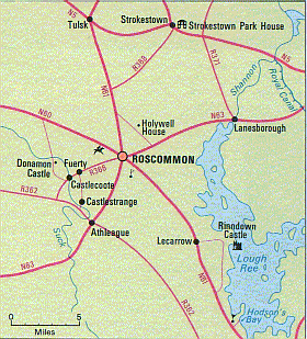
To explore the region west of the Shannon, take the N61 from Athione for 32 km/20 mi to Roscommon, the capital of County Roscommon, where sheep and cattle raising is the main occupation. As you enter this pleasant little town on the southern slopes of a hill, you'll pass the remains of Roscommon Abbey on your right. The principal ruin is a church; at the base of the choir stand eight sculpted figures representing gallowglasses, or medieval Irish professional soldiers. The ruins are freely accessible. To the north of the town are the weathered remains of Roscommon Castle, a large Norman stronghold dating from the 13th century. After seeing it, wander around the town center, a quiet place with buildings designed mainly in late-Georgian and Victorian styles. Note the Bank of Ireland in the main square: This gracious Georgian building, once the courthouse, served as the Catholic Church until 1902.
Those with an interest in fishing and walking will want to continue north on the N61 for 43 km/26 mi to Boyle, a delightful, old-fashioned town situated on the Boyle River midway between Lough Gara and Lough Key. The ruins of Boyle Abbey (on the N4), dating from the late 12th and early 13th centuries, still convey an impression of the splendor of this richly endowed Cistercian foundation. The nave, choir, and transept of the cruciform church are in good condition. The ruins are freely accessible.
Boyle is a mecca for anglers and walkers who can choose between the challenges of the Curlew Mountains to the north of the town, or Lough Key Forest Park to the east, a popular base for campers and backpackers. The park consists of 340 hectares/840 acres on the shores of the lake, and contains a bog garden, a deer enclosure, and a cypress grove; boats can be hired on the lake.
The main tour leaves the N61 after about 12 km/8 mi at Tulsk, turning right (east) on to the N4 for Strokestown Park House. Like many villages near a "big house," Strokestown was designed to complement the house. The widest main street in Ireland-laid out to rival the Ringstrasse in Vienna-leads to a Gothic arch, the entrance to the house grounds. As you can see from its facade, this enormous house, seat of the Pakenham Mahon family from 1660 to 1979, has a complicated architectural history. The Palladian wings were added in the 18th century to the original 17th-century block, and the house was extended again in the early 19th century. The interior is full of curiosities, such as the gallery above the kitchen, which allowed the lady of the house to supervise domestic affairs from a safe distance. Menus were dropped from the balcony on Monday mornings with instructions to the cook for the week's meals. One wing houses lavish stables with vaulted ceilings and Tuscan pillars. There is also a distillery and a fully equipped nursery. The gardens are undergoing an ambitious restoration plan that will include the widest and longest herbaceous borders in Ireland. A museum documenting local events during the disastrous Famine (1845-1850) opened in 1994.
rule.gif (2124 bytes)
The following data is courtesy of Best of Ireland:
Roscommon is an inland county where the main attraction is the beauty of island-dotted lakes. Much of the county is level plain, bogland and river meadow - broken with low hills and many lakes. The highest point (1,385 feet) is on the County Leitrim border in the north; also prominent are the Curlew Hills (867 feet) in the north-west and the Slievebawn hills (864 feet in the east. The county's eastern boundary is formed by the River Shannon and its lakes.
The following data is courtesy of Ireland Now:
Located on Ireland's fertile central plain, the county has an area of 2,463 sq km (951 sq mi). The soil is most fertile in the central district, east of the town of Boyle. Livestock raising and agriculture are economically important. Sheep are raised in the highlands, oats and potatoes are grown, and coal is mined in the hills.
Most of the county is situated between the Shannon River, to the east, and its chief tributary, the Suck River, to the west. The land is undulating, with natural grazing areas interspersed with rocky outcrops, lakes, and peat bogs.
Peat, compact, dark brown organic material with high carbon content, built up by the partial decay and carbonization of vegetation in the acid water of bogs. In the northern hemisphere, peat-forming vegetation consists mostly of mosses. The formation of peat represents the first stage in the transformation of vegetation into coal. Dried peat, often compressed into briquettes, is used in many European countries, particularly Ireland, as a fuel, although it is not as efficient as coal because of its large content of water and ash.
A large part of Roscommon belonged to the O'Kelly family before the English invasion of the area in the 17th century. It continued to remain isolated from England after the occupation.
Area : 2,460 km² (951 sq mi)
Population (1991): 51,897
Average population density: 21.1 per km²
Major Towns:
Ballaghderreen (1,270)
Boyle (2,197)
Castlerea (1,822)
Elphin
Loughlynn
Knockcroghery
Roscommon (3,427)
Strokestown
Suggested Places to visit:
Arigna Scenic Drive
Ballintober Castle
Boyle Abbey
Castlestrange Stone
Clonalis House
King House interpretive center (Boyle)
Lough Key Forest Park
Roscommon Castle and Friary
Strokestown Park House
Major lakes:
Allen
Gara
Key
Major rivers:
Boyle
Shannon
Suck
Highest Point : Corry Hill, 422m (1,385 feet)
Roscommon is part of the province of Connacht and is governed as part of the Republic of Ireland. The county town is also Roscommon, and the name derives from Ros-Comain meaning ' wood around a monastery.'
The following data is courtesy of Fodor's Guidebooks:
To explore the region west of the Shannon, take the N61 from Athione for 32 km/20 mi to Roscommon, the capital of County Roscommon, where sheep and cattle raising is the main occupation. As you enter this pleasant little town on the southern slopes of a hill, you'll pass the remains of Roscommon Abbey on your right. The principal ruin is a church; at the base of the choir stand eight sculpted figures representing gallowglasses, or medieval Irish professional soldiers. The ruins are freely accessible. To the north of the town are the weathered remains of Roscommon Castle, a large Norman stronghold dating from the 13th century. After seeing it, wander around the town center, a quiet place with buildings designed mainly in late-Georgian and Victorian styles. Note the Bank of Ireland in the main square: This gracious Georgian building, once the courthouse, served as the Catholic Church until 1902.
Those with an interest in fishing and walking will want to continue north on the N61 for 43 km/26 mi to Boyle, a delightful, old-fashioned town situated on the Boyle River midway between Lough Gara and Lough Key. The ruins of Boyle Abbey (on the N4), dating from the late 12th and early 13th centuries, still convey an impression of the splendor of this richly endowed Cistercian foundation. The nave, choir, and transept of the cruciform church are in good condition. The ruins are freely accessible.
Boyle is a mecca for anglers and walkers who can choose between the challenges of the Curlew Mountains to the north of the town, or Lough Key Forest Park to the east, a popular base for campers and backpackers. The park consists of 340 hectares/840 acres on the shores of the lake, and contains a bog garden, a deer enclosure, and a cypress grove; boats can be hired on the lake.
The main tour leaves the N61 after about 12 km/8 mi at Tulsk, turning right (east) on to the N4 for Strokestown Park House. Like many villages near a "big house," Strokestown was designed to complement the house. The widest main street in Ireland-laid out to rival the Ringstrasse in Vienna-leads to a Gothic arch, the entrance to the house grounds. As you can see from its facade, this enormous house, seat of the Pakenham Mahon family from 1660 to 1979, has a complicated architectural history. The Palladian wings were added in the 18th century to the original 17th-century block, and the house was extended again in the early 19th century. The interior is full of curiosities, such as the gallery above the kitchen, which allowed the lady of the house to supervise domestic affairs from a safe distance. Menus were dropped from the balcony on Monday mornings with instructions to the cook for the week's meals. One wing houses lavish stables with vaulted ceilings and Tuscan pillars. There is also a distillery and a fully equipped nursery. The gardens are undergoing an ambitious restoration plan that will include the widest and longest herbaceous borders in Ireland. A museum documenting local events during the disastrous Famine (1845-1850) opened in 1994.
rule.gif (2124 bytes)
The following data is courtesy of Best of Ireland:
Roscommon is an inland county where the main attraction is the beauty of island-dotted lakes. Much of the county is level plain, bogland and river meadow - broken with low hills and many lakes. The highest point (1,385 feet) is on the County Leitrim border in the north; also prominent are the Curlew Hills (867 feet) in the north-west and the Slievebawn hills (864 feet in the east. The county's eastern boundary is formed by the River Shannon and its lakes.
The following data is courtesy of Ireland Now:
Located on Ireland's fertile central plain, the county has an area of 2,463 sq km (951 sq mi). The soil is most fertile in the central district, east of the town of Boyle. Livestock raising and agriculture are economically important. Sheep are raised in the highlands, oats and potatoes are grown, and coal is mined in the hills.
Most of the county is situated between the Shannon River, to the east, and its chief tributary, the Suck River, to the west. The land is undulating, with natural grazing areas interspersed with rocky outcrops, lakes, and peat bogs.
Peat, compact, dark brown organic material with high carbon content, built up by the partial decay and carbonization of vegetation in the acid water of bogs. In the northern hemisphere, peat-forming vegetation consists mostly of mosses. The formation of peat represents the first stage in the transformation of vegetation into coal. Dried peat, often compressed into briquettes, is used in many European countries, particularly Ireland, as a fuel, although it is not as efficient as coal because of its large content of water and ash.
A large part of Roscommon belonged to the O'Kelly family before the English invasion of the area in the 17th century. It continued to remain isolated from England after the occupation.
