Ballon Hill
- On the top of Ballon Hill were formerly large and curious
entrenchments. Cathair Mor, King of Ireland was slain in the year 177
and was buried at Enach Ailbhe. Fr. Shearman identifies this with Ballon
Hill. Enach Carmen, where the ancient games of mid-Leinster were
celebrated seems to have been on the north-west side of Mount Leinster
on the border of Ballon parish. Enach Carman was on the river Burren
which was called Borrinn Carmen, the rocky place of Burren. The Hill of
Ballon was connected with the funeral rites practised at these games.
The hill was extensively used as a cemetery by the pagan Irish. This is
shown by the large number of sepulchral urns that have been discovered
there.
- These may be seen in the National Museum.
http://www.ballonvillage.com/Ballon Hill.htm
Archaeology and Antiquities
Professor MacAllister wrote:
“Time was when some of us were taught not only to look upon
ourselves as aliens in our native land, but even to glory in so being:
and to anticipate with craven terror any political change that would de-alienize
us: when our teachers were busy spinning cobwebs of prejudice and of a
soul-destroying utilitarianism. Some there be, even yet, who have never
succeeded in rubbing these away. But those who have done so have reaped
a rich reward. They have seen a vision, overwhelming as that of the
Hebrew prophet’s henchman in the days of old: to whose purblind sight,
suddenly illuminated as with a Divine flash, were revealed mystic
companies of fiery chariots and horses, marshalled on the ancient
hills.”
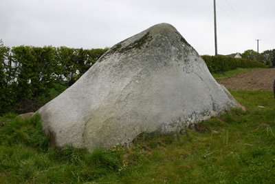
Clochan na Marbhan
The stone called Clochan na Marbhan on Ballon Hill consists of a
large block of granite of a pyramidal shape standing some eight feet
high. On dearing away the soil three skeletons were found: a bed of
charcoal, and some broken urns were unearthed. On continuing the
excavations on the site of the ancient Rath a large urn, resting
 in an
inverted position and quite perfect was brought to light. A cist filled
with sand and a broken dagger-blade (the only implement found during the
excavations) came to light. On continuing the operations here a large
walled up chamber, covered with an enormous flag calculated to weigh
almost a ton, was found. This chamber was filled with charred bones. The
collection of Bronze Age pottery of the late Colonel Beauchamp Lecky D.S.O.
is now in the National Museum in Dublin. This important collection
consists of:
in an
inverted position and quite perfect was brought to light. A cist filled
with sand and a broken dagger-blade (the only implement found during the
excavations) came to light. On continuing the operations here a large
walled up chamber, covered with an enormous flag calculated to weigh
almost a ton, was found. This chamber was filled with charred bones. The
collection of Bronze Age pottery of the late Colonel Beauchamp Lecky D.S.O.
is now in the National Museum in Dublin. This important collection
consists of:
- Two large cinerary urn’s
- Two rims of similar ones
- Four smaller
cinerary urns
- Eight food vessels
- Fragments of another decorated vessel
and a pot-shaped vessel.
In addition to this collection from the old pre-historic cemetery
on Ballon Hill, the Lecky collection includes:
- A bronze leaf-shaped sword
- A socketed bronze spearhead
- Two socketed bronze axes
- The point of a bronze sickle and Human remains.
The Bronze Age pottery and other finds on Ballon Hill and in the
neighbourhood were brought to light in the excavations of 1852-1854 and
subsequent years. A great number of the “finds” here, urns etc., were
broken in the process of excavation, and some specimens being only
sun-dried, fell to pieces on exposure to the air. The residue of the
finds was housed at Baile Ui Caolaidhe, the residence of ‘the Lecky
family until the transference of the finds to the National Museum, a few
years ago.
Source: Ballon and Rathoe Vol. 1 Peadar Mac Suibhne
1980
Image source:
http://ballonvillage.com/
The Bronze Age
- Archaeologists are wont to classify their discoveries, the remains
of antiquity as belonging to the:
- 1. STONE AGE, the period when stone implements were most in use.
- 2. BRONZE AGE, the discovery of bronze, copper and tin compounds
gave their name to this Age.
- 3. IRON AGE, the Iron Age succeeded and is still with us.
- 4. Archaeologists of our day draw no sharp line of division
between the Stone and Bronze Ages, and even in the Iron Age down to
our own time one might find a stone hammer in the country forge.
-
- Source: Ballon and Rathoe Vol. 1 Peadar Mac
Suibhne 1980
Top
Idrone (Ui Drona)
The barony of Idrone East is in the south of County Carlow. It is
bounded on the north by the barony of Carlow, on the south by the barony
of St. Mullins Lower., on the east by the barony of Forth, on the
south-east by the barony of Scarawalsh (Co. Wexford), on the west by the
River Barrow, and on the north-west by the barony of Idrone West. Its
area (including that of Idrone West) is 45,715 acres, of which 38,615
are arable and 7,100 are mountain and bog. It contains the following
civil parishes: Slyguff Kiltennell Dunleckney Ballyellen (part of)
Nurney and Agha (part of) Fenagh (part of) Loram.
The chain of the Blackstairs mountain’s separates it from the
County Wexford. It was formerly inhabited by a tribe called the Ui
Drona. The Ui Drona (Nepotes Dronai), who took the surname of O’Rian or
O’Ryan are descendants of Eana Cinnselagh, whose sobriquet “Dron”
(Genitive Dronai), they assumed as their tribe name. They occupied the
territories of the Fotharta, and in addition, the land west of the
Barrow encroaching on the Ossorian territory, now comprised in the
barony of Idrone West. Idrone East was part of the Fotharta. (Loca
Patriciana, p. 210).
O’Huidhrin refers to these territories: Pass across the Bearbha
(Barrow) of the cattle borders, From the land of corn and rich honey,
From Dinnrigh to Maistin the strong (Mullaghmast) My journey is paid for
by their nobility.
Hereditary to O’Riaghain (O’Ryan) of smooth land, Is a celebrated
cantred, long the land, Ui Drona of the pleasant hills, More profitable
to him than a strange territory.
O’Neill of fair Magh da Chon Who has taken a step against the
Gaels.
In an explanatory note on Ui Drona O’Donovan says:-‘- “This tribe,
descended from Drona, the fourth in descent from Cathair Mor monarch of
Ireland in the second century, gave its name to the barony of Idrone, in
the County Carlow.” Of Magh da Chon, “the plain of the two hounds,” he
says:-‘- “This name is now anglicised Moyacomb, a parish in the barony
of St. Mullins (Lr.) in the County Carlow, and extending into the barony
of Shillelagh, County Wicklow. It is sometimes called Fearann O’Neill.
O’Neill of this territory is now unknown.” The Onomasticon (p. 157)
equated Idrone with Cliu thus:- “Carmen was in or near Idrone (Cliu,
genitive Cliach)” and again:-‘- “Cliu: genitive Cliach, dative Dliu . .
. in Idrone, County Carlow: Conaire (Mor) slew Neadu Necht in the battle
of Cliach in Ui Drona (Book of Leinster 23.a).”
Father Shearinan spells
the name Cliu and says it was a primitive and remarkable locality in the
territory of the Ui Drona, adjoining the Fothart now in the baronies of
Idrone East and Forth, with part of the Ui Felmetha (Tullow). About the
beginning of the Christian era (recte 145-152 A.D.) Nuada Necht, King of
Leinster, was slain at Cliu in Ui Drona by Conaire Mor, King of Ireland
(Loc. Pat. p. 141).
Dr. O’Connor in the Ordnance Survey Letter dated
Carlow, July 5th, 1839, went to some rounds to prove that Cliach was
identifiable with Cloydah about two miles from Carlow town. He states:-
“Cliach is placed in Idrona at A.M. 5090 in the ‘Annals of the Four
Masters,’ whom he quotes as follows:- A.M. 3773. Eochaidh, having
enjoyed for 21 years the sovereignty of Ireland was slain by Aengus
Olmhuadha in the battle of Cliach. A.M. 5090 Nuadha Neacht, son of Sedna
Sitbaic, after ruling for half a year the kingdom of Ireland, was slain
in the battle of Cliach in Ui Drona by Conaire the Great. A.D. the
battle of Eibhlinn (was fought) by Murcertagh son of Erca. The battle of
the plain of Ailbe (Magh Ailbhe); the battles of Almain (Allen); the
battle of Cinneich (Kinneagh) and the slaughter of the Cliachs.
- Source: Ballon and Rathoe Vol. 1 Peadar Mac
Suibhne 1980.
Top
Dinn Righ
The King’s Stronghold
This place is in the Parish of Leighlin, about five miles west of
Ballon, but as it was intimately associated with the early history of
South Leinster, no account of places in Forth’ and Idrone would be
complete without some reference to it. Keating tells us that the royal
seats that were in Leinster, where the kings of the country kept their
court, were Dinrigh and the Nas (Naas) (p. 17).
For hundreds of years
the exact location of the royal residence of Dinn Righ seemed to have
been unknown or forgotten, although Keating mentions it, and indicates
its position in the preface to his history of Ireland. “Dumha Slainghe
(otherwise called Dion Riogh) situated upon the bank of the Bearow
(Barrow), between Catherlagh (Carlow) and Laghlen (Leighlin), upon the
west side of that river. Acting upon the reference it is evident that
John O’Donovan instructed his co-workers in the Ordnance Survey of 1837
to examine the banks of the Barrow very closely so as to find, if
possible, the exact position of the dun.
Dr. O’Connor wrote from Carlow
on 16th June, 1837, stating - ‘In going along the Barrow we made every
effort but were unable to find Dinn Righ.’ But on June 19th he wrote
from Leighlin Bridge. “Near Ballyknockan, and contiguous to the road
leading to the Royal Oak, is one of the ancient raths, of very
considerable extent. It is called Maudlin Moat by the peasantry.” The
Moat measured 237 yards in circumference at the base, 69 feet high from
the level of the Barrow, and 135 feet in diameter at the top. He
proceeds: “Though the ancient name of this Moat is not remembered, there
is still every certainty that it is Dionn Righ, which was the palace of
the Leinster Kings. . .
The situation of the feature (the Moat)
described in this letter, though it is not in a direct line between
Carlow and Old Leighlin, agrees in every other respect with that of
Dionn-Righ as given by O’Flaherty and Keating (already cited).” He notes
that the Barrow formerly ran a little further to the west, and nearer to
the Moat than it was on the occasion of his visit, and says:- “The high
ground which the Moat occupies was then (in Keating’s time) the bank
(brink) of the river. Indeed it may be properly so called still.” The
very character of the Moat as to size and form testifies much to the
truth of the identity.
- Source: Ballon and Rathoe Vol. 1 Peadar Mac
Suibhne 1980
The Four Masters Wrote:
“A.M. 3267, Slainge, the son of Dala, was in the government of
Ireland during the space of one year, and died in the end of that year
in Dionn Righ on the Bank of the Barrow.” A.M. 4658 “Codthach Caolbreagh,
son of Ugaine the Great, having been fifty years in the government of
Ireland, was slain by Labhra Loingseach, Maen, son of Oilioll the Noble,
together with thirty kings (princes) in Dionn-Righ on the bank of the
Barrow.”
- Source: Ballon and Rathoe Vol. 1 Peadar Mac
Suibhne 1980
O’Flaherty wrote In Ogygia:
The Belgians (Firbolgs) were the first who instituted a kingly
government in Ireland; the five brothers (Slainge, Gann and Seangann
with Geanann and Rughraidhe, heroes all), having entered into a compact
to reign alternately, Slairige was proclaimed the first monarch of
Ireland. At the expiration of one year he was interred at Dumha-Slainge
(now Denrigia on the banks of the river Barrow between Carlow and
Leighlin) in Leinster. (Vol. ii., Chap. LX., p. 16).
The Naval Lavrad
(Lowry) the grandson of King Laogar Lorc, by the death of his
predecessor, obtained the Kingdom (of Ireland). Lavrad, after the murder
of his father and grandfather, being banished into Gaul, in a few years
after, brought a great number of strangers in a large fleet (for which
reason he got the epithet Naval) into the harbour of Wexford.
Afterwards
he rushed into the palace of Cobthach (Coffa the Slender) at Dinnrigia,
near the river Barrow, and put the King and thirty of the nobility to
the sword, and laid the palace in ashes. Vol. ii., Chap. IX., p. 137.
“Dinn Righ means the Hill of the Kings,” said Dumha Slainge, “Slainge’s
Mount.” In the poems of Dubhtach Mac Ui Lugair it is called Tuam Tenba:
“It is difficult to contend with Leinstermen In manly actions. Labhraidh
Loinseach it was that killed Cobhtach At Tuam Tenba.”
The ancient Dinn Ree, then, is now known as Maudlin Moat, in the
townland of Ballyknockan. It is on the west side of the Barrow, on the
road from Leighlin Bridge to the Royal Oak
- Source: Ballon and Rathoe Vol. 1 Peadar Mac
Suibhne 1980