
![]()
Poor Law Unions
![]()
|
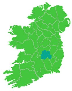
On July 31, 1838, the Poor Law act was enacted
which divided Ireland into Poor Law Unions. By 1847, there were 130
unions and later some of these were divided into two or more unions
so that by 1864 there were a total of 163 unions. |
![]()
![]()
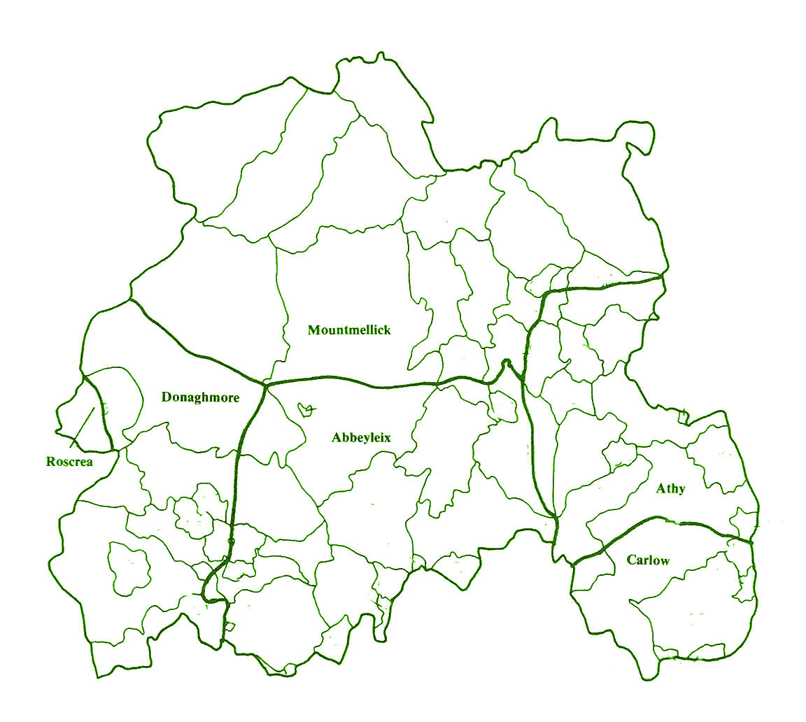
| Ballylynan
D. Area: 21,758, Pop. 3,531 |
Stradbally
D. Area: 26,261, Pop. 4,441 |
| Ballyadams E.D. Area, 4,311, Pop. 548 Ballyadams B., Ballyadams P. Ballintlea Ballintubbert Ballyadams Cappanafeacle Crannagh Kellyville Monascreeban Ratherrig Rathmore Southfield Sronscull St John's P. Rosbran |
Curraclone E.D. Area 3,159, Pop. 384 Stradbally B., Ballyadams P. Drummeen Curraclone P. Ballyduff Ballykilcavan Bawn Binbawn Blackford Curraclone Garrans Inch Knockphilip Kylebeg Mill Land Park |
| Ballylynan E.D. Area 3,538, Pop. 957 Ballyadams B., Ballyadams P. Fallaghmore Loughlass Parkahoughill Killabban P. Aghanure Ballylynan Rahin Rathaspick P. Corbally |
Luggacurren E.D. Area 6,008, Pop. 623 Ballyadams B., Tullomoy P. Tullomoy Stradbally B., Tullomoy P. Brennanshill Clopook Coolglass Coolrusk Fallowbeg, Lower Fallowbeg, Middle Fallowbeg, Upper Fernyhill Gorreelagh Guileen Knockahonagh Luggacurren Manger Monamanry Raheenbarnagh Raheennahown Scotland Tomoclavin |
| Barrowhouse E.D. Area 3,190, Pop. 321 Ballyadams B., Ballyadams P. Drumroe Dunbrin, Lower Dunbrin, Upper Garroonagh Killyganard Rathgilbert Whitebog Tankardstown P. Barrowhouse Graigue Shanganagh Beg Shanganagh More |
Moyanna E.D. Area 4,128, Pop. 647 Stradbally B., Moyanna P. Ballynowlan Ballyrider Correel Garrymaddock Kilrory Kylespiddoge Moyanna Raheenaniska Raheennahown, North Raheennahown, South Rathcrea Rosnamullane Rossmore Tonafarna |
| Killabban E.D. Area 3,140, Pop. 442 Ballyadams B., Killabban P. Ballyfoyle Ballynagarr Coolgarragh Killabban Killeen Monksgrange P. Grange |
Stradbally E.D. Area 5,105, Pop. 2,010 Stradbally B., Dysartenos Grange, Lower Grange, Upper Oldmill Park, Lower Park, Upper Raheenduff Kilteale P. Ballymaddock Stradbally P. Aghamaddock Ballaghmore Brockleypark Carricksallagh Knocknambraher Kylebeg Newtown Oughaval Rathmore Stradbally Tursalla |
| Rathaspick E.D. Area 3,703, Pop. 711 Ballyadams B., Rathaspick P. Aghamafir Boley Crissard Gracefiled Inch Kellystown Kilfeacle Kylenabehy Mullaghmore Rathaspick Shanragh Wolfhill |
Timogue E.D. Area 4,779, Pop. 437 Stradbally B., Dysartenos P. Banteogue Bigbog Killalooghan Killavally Loughteeog Powelstown Raheenanisky Fossy or Timahoe P. Carrigeen Derrytrasna Money, Lower Money, Upper Powelstown Timogue P. Ballinateskin Ballycoolan Ballyprior Clondoolagh Guileen Timogue |
| Tankardstown E.D. Area 3,786, Pop. 552 Ballyadams B., Killabban P. Ballinree Ballybeg Cullenagh Kilmorony Maghareagh Milford Monebrock Tankardstown |
Vicarstown E.D. Area 3,082, Pop. 340 Stradbally B., Curraclone P. Ballymanus Correel Portree Moyanna P. Derrybrock Vicarstown (Cosby) Vicarstown (Dodd) |
| Abbeyleix
D. Area: 18,878 Pop: 4,435 |
Ballinakill
D. Area: 25,602 Pop: 3,431 |
Ballyroan
D. Area: 20,012 Pop: 3.243 |
Castletown
D. Area: 18,631 Pop: 2,714 |
Durrow D. Area: 24,044 Pop: 4,168 |
| Abbeyleix E.D. Area: 10,022 Pop: 4,435 Cullenagh B. Abbeyleix P. Abbeyleix Demesne Ballymaddock Ballymullen Ballytarsna Blackhills Boley Brandra Clonkeen Clonoghil Curnagnacronacon Derrylahan Granafallow Island Killamuck Knapton Knocknamoe Poormansbridge Rathmoyle Redhills Tonduff Tullyroe Clonenagh & Clonagheen P Boley, Lower Dysartgallen P. Ralish |
Ballinakill D. Area: 4,905 Pop: 1,417 Cullenagh B. Abbeyleix P. Ironmills or Kilrush Lisbigney Dysartgallen P. Ballinakill Boleybown Cappanashannagh Cloghoge Drimaterril Glebe Haywood Demesne Kilcronan Kilnashane Moneycleare Baggettstown Rosconnell P. Moneycleare |
Ballyroan E.D. Area: 5,521 Pop: 1,075 Cullenagh B. Ballygroan P. Ballinlough Ballyroan Ballyrain Cashel Cloncullane Crubeen Dooary Mounteagle Raheenabrogue Clonenagh & Clonagheen P Mounteagle |
Caher E.D. Area: 18,632 Pop: 2,714 Upperwoods B Offerland P. Caher (Custodia) Caher(Retrenched) Derryarrow Gortavoata Kildrinagh Mondrehid The Derries Toortaun Windsor or Cappaghnahoran |
Aghmacart E.D. Area: 4,673 Pop: 551 Clarmallagh B. Aghmacart P. Ballykealy Craigueavoice Derreen and Carrowreagh Knocknagrally or Killenny Beg Newtown Toberboe or Killenny More Aharney P. Aharney Archerstown Ballykealy |
| Clash E.D. Area: 3,741 Pop: 629 Maryborough West B. Clonenagh & Clonagheen P Boley, Upper Cappanacloghy Killeany Scotchrath Shanahoe Springmount |
Blandsford E.D. Area: 5,087 Pop: 593 Cullenagh B. Ballyroan P. Ballyglishen Ballyking Ballypickas Lower or Bernardsgrove Ballypickas, Upper Clontycoe Derryfore Drumashellig Rahanavannagh Tullore Dysartgallen P. Boleybeg Clarbarracum Clontycoe Coole or Lisnagomman Garrintaggart Graiguenasmuttan Lisnagomman |
Clonkeen E.D. Area: 6,484 Pop: 1,064 West Maryborough B Clonenagh & Clonagheen P Ardlea Ballynamuddagh Clonadacasey Clonaddadoran Clondouglas or Clonkeen Clonkeen Coolmacartan Fatharnagh Oldtown Rosskelton |
Castletown E.D. Area: 5,978 Pop: 905 Upperwoods B. Offerland P. Aghafin Ballytarsna Bohernaghty Butterisland Camphill Cashel Churchfield Churchtown Clashnamuck Cookesfield Crossfield Danganroe Elderfield Gash Knockacoller Knockbrack Lowran Mannin Newtown Oldborris Peafield Pilgrimhill Rush Hall Shangownagh |
Cullahill E.D. Area: 4,180 Pop: 541 Clarmallagh B. Aghmacart P. Ballynevin Barrackquarter or Ross Bunlacken Castlequarter Cullahill Mountain Galesquarter Oldtown Parknahown Raheenleagh Scrub and Glenmacolla Shanbally Spaquarter Glashare P. Gorteennahilla |
| Colt E.D. Area: 2,490 Pop: 331 Maryborough West B. Clonenagh & Clonagheen P Colt Clorbally |
Dysartgallen E.D. Area: 5,145 Pop: 557 Cullenagh B. Dysartgallen P. Agnacross Cleanagh Graigue Graiguenahown Keelagh Knockardagur Knockbaun Moat Moyadd |
Cullenagh E.D. Area: 2,077 Pop: 253 Cullenagh B. Ballygrean P. Ballyhagland Baunree Cullenagh Kilvhan Pass Fossy or Timahoe P. Baunree Raheenduff, Big Kilcolmanbane P. Ballyheyland Kilvahan Pass |
Cuffsborough E.D. Area: 4,869 Pop: 752 Clarmallagh B. Aghahoe P. Anster Ballycuddahy Ballygeehin, Lower Ballygeehin, Upper Ballygowdan Ballyowen Boherard Chapelhill Coolfin Cruell Cuffsborough Dairyhill Farraneglish Glebe Fearagh Gortnaclea Gortnagroagh Knockamullin Leap Legaun Springfield or Knockkyle Tinnaraheen Bordwell P. Chapelhill |
Durrow E.D. Area: 6,427 Pop: 1,582 Clarmallagh B. Attanagh P. Ballynafunshin Glebe Grenan Durrow P. Capponellan Castledurrow Demesne Castleview Castlewood Clonageers Course Durrow Townparks Fermoyle Glebe Grenan Knockanoran Moyne Tinwear Rosconnell P. Ballynafunshin Clorhaun Fermoyle Grenan Gurraun Raheenduff Rosconnell Glebe |
| Dunmore E.D. Area: 2,625 Pop: 346 Clarmallagh B. Abbeyleix P. Baggotspark Coolcorberry Dunmore Graceswood Kyle Parkbawn Stewartsgrove Watercastle Durrow P. Coolcorberry Dunmore Kylebeg Loughnamuck Rath Stewartsgrove Swan |
Fossy E.D. Area: 4,053 Pop: 388 Cullenagh B. Fossy or Timahoe P Aghadreen Bannogemeely Clashboy Fossy, Lower Fossy, Upper Knockacrin Knocklead Orchard, Lower Orchard, Upper |
Baheen E.D. Area: 4,920 Pop: 843 West Maryborough B. Clonenagh & Clonagheen P. Barnadarrig Bawnaree Clonwoolan Clonbane Cloncough Clondouglas Cloosecullen Coole Cromage Derrykearn Derryroe Doon Foxburrow Mountfead Parkavilla Raheen Tarbert Tinnakill |
Donore E.D. Area: 5,724 Pop: 820 WestMaryboroughB Abbeyleix P. Boston or Coolballyogan Clonenagh & Clonagheen P. Clonard or Cappaloughlin Clonrud Forest Upperwoods B. Offerlane P. Badgerisland Ballycleary Boston Camcloon Castletrench Clonfad Coole Corrigeen Cuddagh Donore Kilbrickan Rathphelan |
Killermogh E.D. Area: 4,639 Pop: 737 Clarmallagh B. Aghahoe P. Ballycolla Ballygarvan Glebe Kilminfoyle Kyletilloge Park Tintore Durrow P. Coolnabehy Killermogh P. Ballycolla Ballycolla Heath Ballygauge Beg Ballygauge More Cool Coolderry Killermogh Park Rathmakelly Glebe Tintore |
| Timahoe E.D. Area: 8,412 Pop: 666 Cullenagh B. Fossy or Timahoe P Aghoney Ballinaclogh, Lower Ballinaclogh, Upper Ballintlea, Lower Ballintlea, Upper Ballygormill, South Coolnabacky Esker Garryglass Kyle Raheenduff, Little Timahoe Kilcolmanbrack P. Cremorgan East Maryborough B Fossy or Timahoe P. Ballygormill, North |
Kilnaskeer E.D. Area: 4,125 Pop: 757 Clarmallagh B. Aghaboe P. Kilnaseer Knockfin Aghmacart P. Addergoole Aghmacart Ballyboodin Braccas Cannonswood Gorteen Kilnaseer Maynabog Rapla Coolkerry P. Graigueanossy Turfarney Rathdowney P. Ballydavin |
![]()
Source for this webpage:
Townlands in Poor Law Unions
A Reprint of Poor Law Union Pamphlets of the General Registrar's Office
by George B. Handran, CG, 1997
last updated September 25, 2008
![]()
![]()
Mary Ann Lubinsky, IGP Co. Leix/Laois Coordinator
If you have Co. Leix/Laois townland info that you
would like to contribute to this site, use below email.

![]()

©2001-Present
Ireland Genealogical Projects