|
|
Kilcon Townland
County Armagh, Northern Ireland
| Civil Parish | Loughgilly |
| Barony | Orior Lower |
| Poor Law Union | Newry |
| Catholic Diocese | Armagh |
| Catholic Parish | Whitecross (Loughgilly) |
|
|
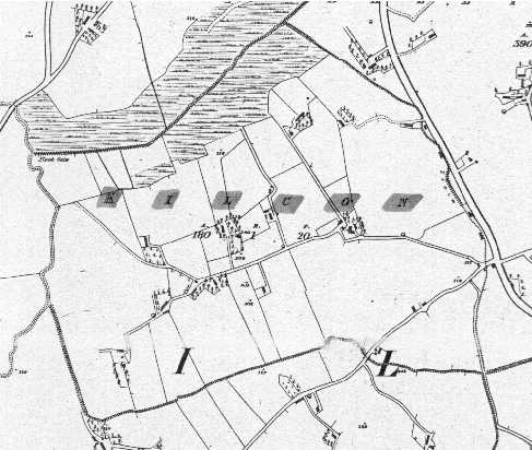
Kilcon in 1835
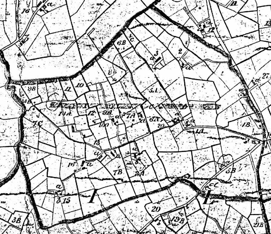
Kilcon in 1864
(The numbers on the farms match the numbers on the Griffith's chart below)
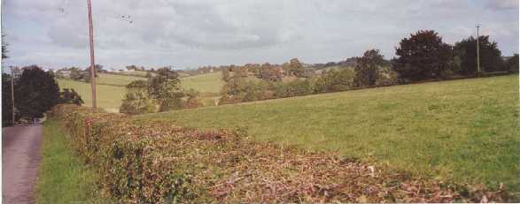
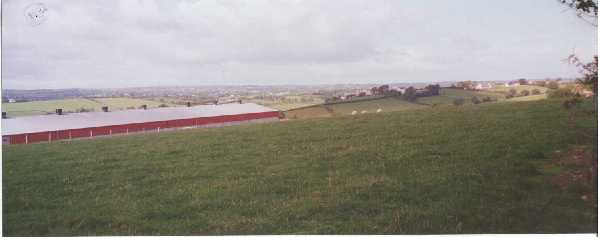
Kilcon in 2005
|
Survey of the School Lands of Mountnorris (1833 and 1878) In 1833, the Commissioners of Education had a survey taken of their lands in Ballymore, Ballyvally, Bolton, Cornagrally, Kilcon, Mavemacullen, and Mullaghmore Townlands in County Armagh. The survey can be found at PRONI in fond D/1607/7. The survey gives a very detailed breakdown of the each tenant's holdings, giving the area and rent of each little section of each holding. If your ancestor lived on Commissioners of Education land, this survey has enough information to allow you to identify the exact plot they were occupying at that time. A similar Commissioners of Education survey taken in 1878 is also located in the same fond.
|
Kilcon Tithe Applotments (1834)
| Gross Area | Roads/ Lakes | Neat Area | Acreable Value | Tithe | |||||||||||
| Occupier | A | R | P | A | R | P | A | R | P | £ | s | d | £ | s | d |
| Samuel Girvin | 14 | 1 | 27 | 2 | 7 | 13 | 3 | 20 | 17 | 1 | 3 | 2½ | |||
| Bridget Mackay | 4 | 1 | 18 | 23 | 4 | 0 | 35 | 17 | 7 | 0½ | |||||
| William Vint | 3 | 3 | 29 | 1 | 9 | 3 | 2 | 20 | 17 | 6 | 1 | ||||
| Archd Girvin | 20 | 3 | 0 | 20 | 3 | 0 | 18 | 1 | 16 | 8½ | |||||
| William Monaghan | 5 | 0 | 0 | 5 | 0 | 0 | 18 | 8 | 10½ | ||||||
| Samuel Shanks | 7 | 2 | 20 | 7 | 2 | 20 | 17 | 12 | 9½ | ||||||
| James Shanks | 7 | 3 | 0 | 7 | 3 | 0 | 17 | 13 | 0 | ||||||
| William Hamill | 9 | 1 | 35 | 9 | 1 | 35 | 18 | 16 | 9½ | ||||||
| William Moreland | 5 | 0 | 10 | 5 | 0 | 10 | 18 | 8 | 11½ | ||||||
| Archd Moreland | 4 | 2 | 30 | 4 | 2 | 30 | 18 | 8 | 3½ | ||||||
| Samuel Hawthorn | 3 | 0 | 20 | 3 | 0 | 20 | 18 | 5 | 6½ | ||||||
| Thos Hawthorn | 25 | 1 | 0 | 25 | 1 | 0 | 16 | 1 | 19 | 9 | |||||
| Samuel Hawthorn Jr | 4 | 1 | 0 | 4 | 1 | 0 | 18 | 7 | 6½ | ||||||
| Samuel Hawthorn Sr | 15 | 2 | 0 | 15 | 2 | 0 | 17 | 1 | 5 | 11¼ | |||||
| James Hawthorn | 12 | 3 | 0 | 12 | 3 | 0 | 17 | 1 | 1 | 4½ | |||||
| Gordon Vint | 10 | 0 | 0 | 10 | 0 | 0 | 17 | 16 | 9¼ | ||||||
| Joseph McKee | 4 | 0 | 20 | 4 | 0 | 20 | 18 | 7 | 4 | ||||||
| Samuel Vint Jr | 10 | 3 | 20 | 10 | 3 | 20 | 18 | 19 | 3 | ||||||
| Samuel Vint Senr | 8 | 3 | 30 | 8 | 3 | 30 | 16 | 14 | 1 | ||||||
|
Total |
177 | 3 | 19 | 0 | 3 | 39 | 176 | 3 | 20 | 14 | 19 | 4 | |||
|
The Gross Area, the Area taken by Roads and Lakes, and the Neat Area (or net area) are given in English acres, roods and perches, where a rood = 40 perches and an acre = 4 roods. One English acre = 43,560 square feet. The value per acre and the total tithe are given in pounds sterling, shillings, and pence, where 1 pound = 20 shillings and 1 shilling = 12 pence. |
Kilcon Griffith's Valuation (1864)
| Area | Annual Tax - Land | Annual Tax - Bldgs | Total Annual Tax | ||||||||||||
| No. | Occupier | Lessor | Description | A | R | P | £ | s | d | £ | s | d | £ | s | d |
| 1 | Samuel Monaghan | Commissioners of Education | House, ofcs, forge & land | 13 | 3 | 5 | 13 | 5 | 0 | 1 | 15 | 0 | 15 | 0 | 0 |
| 2 | Elim Vint | Commissioners of Education | House, ofcs & land | 6 | 3 | 0 | 6 | 10 | 0 | 1 | 0 | 0 | 7 | 10 | 0 |
| 3 | Thomas Porter | Commissioners of Education | House, ofcs & land | 9 | 2 | 20 | 9 | 5 | 0 | 1 | 0 | 0 | 10 | 5 | 0 |
| 4A,4Aa | Margaret Girvin | Commissioners of Education | House, ofcs & land | 16 | 3 | 5 | 18 | 0 | 0 | 4 | 10 | 0 | 26 | 0 | 0 |
| 4B | Margaret Girvin | Commissioners of Education | Land | 2 | 3 | 10 | 3 | 5 | 0 | 0 | 0 | 0 | ) | ||
| 4C | Margaret Girvin | Commissioners of Education | Land | 0 | 3 | 20 | 0 | 5 | 0 | 0 | 0 | 0 | ) | ||
| 4Ba | James Browne | Margaret Girvin | House and garden | 0 | 1 | 10 | 0 | 10 | 0 | 1 | 0 | 0 | 1 | 10 | 0 |
| 5A,5Aa | Robert Girvin | Commissioners of Education | House, ofcs & land | 9 | 2 | 0 | 9 | 15 | 0 | 4 | 0 | 0 | 37 | 15 | 0 |
| 5B | Robert Girvin | Commissioners of Education | Land | 22 | 2 | 25 | 24 | 0 | 0 | 0 | 0 | 0 | ) | ||
| 5Ba | Unoccupied | Robert Girvin | House | 0 | 0 | 0 | 0 | 0 | 0 | 1 | 10 | 0 | 1 | 10 | 0 |
| 5Bb | Eleanor Rice | Robert Girvin | House | 0 | 0 | 0 | 0 | 0 | 0 | 0 | 10 | 0 | 0 | 10 | 0 |
| 5Bc | Sarah Porter | Robert Girvin | House | 0 | 0 | 0 | 0 | 0 | 0 | 0 | 15 | 0 | 0 | 15 | 0 |
| 6A | Samuel Hawthorne Sr | Commissioners of Education | Land | 2 | 1 | 0 | 2 | 10 | 0 | 0 | 0 | 0 | 2 | 15 | 0 |
| 6B | Samuel Hawthorne Sr | Commissioners of Education | Land | 1 | 0 | 30 | 0 | 5 | 0 | 0 | 0 | 0 | ) | ||
| 7A,7Aa | Samuel Hawthorne Sr | Reps. Francis Cope | House, ofcs & land | 12 | 2 | 25 | 12 | 10 | 0 | 2 | 0 | 0 | 19 | 5 | 0 |
| 7B | Samuel Hawthorne Sr | Reps. Francis Cope | Land | 4 | 2 | 0 | 4 | 15 | 0 | 0 | 0 | 0 | ) | ||
| 7C | Samuel Hawthorne Sr | Reps. Francis Cope | Land | 6 | 0 | 30 | 6 | 15 | 0 | 0 | 0 | 0 | 6 | 15 | 0 |
| 7Ba | Mrs. Burke | Samuel Hawthorne Sr | House | 0 | 0 | 0 | 0 | 0 | 0 | 0 | 5 | 0 | 0 | 5 | 0 |
| 8A,8Aa | Samuel Hawthorne Jr | Reps. Francis Cope | House, ofcs & land | 6 | 0 | 20 | 7 | 5 | 0 | 0 | 10 | 0 | 4 | 15 | 0 |
| 8B | Samuel Hawthorne Jr | Reps. Francis Cope | Land | 2 | 0 | 10 | 1 | 0 | 0 | 0 | 0 | 0 | ) | ||
| 8Ab | John McKee | Samuel Hawthorne Jr | House | 0 | 0 | 0 | 0 | 0 | 0 | 0 | 10 | 0 | 4 | 10 | 0 |
| 9A | Samuel Mullins | Reps. Francis Cope | House, ofcs & land | 9 | 1 | 20 | 9 | 0 | 0 | 1 | 15 | 0 | 12 | 0 | 0 |
| 9B | Samuel Mullins | Reps. Francis Cope | Land | 1 | 0 | 15 | 1 | 5 | 0 | 0 | 0 | 0 | ) | ||
| 10 | James Mullins | Reps. Francis Cope | Land | 1 | 1 | 10 | 0 | 10 | 0 | 0 | 0 | 0 | 0 | 10 | 0 |
| 11 | John Mullins | Reps. Francis Cope | Land | 1 | 1 | 15 | 0 | 15 | 0 | 0 | 0 | 0 | 0 | 15 | 0 |
| 12 | James Vint | Reps. Francis Cope | Land | 1 | 3 | 35 | 2 | 5 | 0 | 0 | 0 | 0 | 2 | 5 | 0 |
| 13 | William Vint | Reps. Francis Cope | House, ofcs & land | 3 | 2 | 10 | 4 | 0 | 0 | 1 | 10 | 0 | 5 | 10 | 0 |
| 14A | Thomas Vint | Reps. Francis Cope | House, ofcs & land | 9 | 2 | 5 | 10 | 5 | 0 | 2 | 0 | 0 | 15 | 0 | 0 |
| 14B | Thomas Vint | Reps. Francis Cope | Land | 2 | 0 | 5 | 2 | 15 | 0 | 0 | 0 | 0 | ) | ||
| 15 | Joseph Irwin | Reps. Francis Cope | Land | 13 | 0 | 25 | 14 | 0 | 0 | 0 | 0 | 0 | 14 | 0 | 0 |
| 15a | James Hawthorne | Joseph Irwin | House and garden | 0 | 0 | 20 | 0 | 5 | 0 | 0 | 15 | 0 | 1 | 0 | 0 |
| 15b | Unoccupied | Joseph Irwin | Offices | 0 | 0 | 0 | 0 | 0 | 0 | 0 | 10 | 0 | 0 | 10 | 0 |
| 16 | James Hawthorne | Reps. Francis Cope | House, ofcs & land | 18 | 3 | 10 | 20 | 0 | 0 | 1 | 15 | 0 | 21 | 15 | 0 |
|
Total |
180 | 1 | 20 | 184 | 15 | 0 | 27 | 10 | 0 | 212 | 5 | 0 | |||
|
The numbers and letters in the left-hand column match up with the corresponding numbers and letters on the Griffith's map of Kilcon (see above). Where a small letter is shown, such as "7Ba", this means that the lessee occupies a house marked "a" on the map within the lessor's property marked "7B". The Area is given in English acres, roods and perches, where a rood = 40 perches and an acre = 4 roods. One English acre = 43,560 square feet. The annual tax on land and buildings and the total annual tax are given in pounds sterling, shillings, and pence, where 1 pound = 20 shillings and 1 shilling = 12 pence. Where ")" appears in the total column, the tax on the parcel is included in the line above. "Ofcs" means Offices. "Bldgs" means Buildings. |
|
KILCON SCHOOLS According to the 1826 survey by the Commissioners of Education (FHL film 1559450), there were 14 schools at that time in Loughgilly Parish. These included 5 Catholic schools in Lesh, Greyhillan, Cornagrally, Carrowmannan, and Tullywinny; 7 Presbyterian schools in Drummilt, Lisdrumchor, Mountnorris, Tullyallen, Keady More, Mavemacullen, and Lisadian; 2 Episcopal schools in Belleek and Creggan Upper; and an independent school in Lisdrumchor. None of the Catholic or Episcopal schools were very convenient to Kilcon; the Greyhillan, Lesh, and Cornagrally Catholic schools were all about the same distance from Kilcon (about 2 miles each) and the Creggan Upper Episcopal and Lisdrumchor Independent schools were slightly closer. The Tullyallen, Mountnorris and Keady More Presbyterian schools were the most convenient, all three being within easy walking distance. In 1826, the headmaster of the Mountnorris school was King Murray, the school was contributed by the Mountnorris Presbyterian Church congregation and was rated "good". The student body included 11 Presbyterians, 13 Catholics, and no Episcopalians, including 15 boys and 7 girls. (These numbers don't add up, but that's what the report says.) The headmaster of the Tullyallen school was Alexander McCullogh, the school was attached to the Tullyallen Presbyterian Church and was rated "good". The student body included 33-35 Presbyterians, 5-7 Catholics, and no Episcopalians, including 23 boys and 17 girls. The headmaster of the Keady More school was William Thompson, the school was held in "a waste hovel", and the student body included 21-27 Presbyterians, 2 Catholics, 0-1 Episcopalians, and 0-7 other denominations, including 17 boys and 13 girls. |
|
Kilcon Land Ownership When Griffith's valuation was taken in 1864, the ownership of Kilcon was divided about 50/50 between Francis Cope (93A, 3r, 15p) and The Commissioners of Education (86A, 2r, 5p). The Commissioners of Education: (1) In 1609, the entire County of Armagh, together with most other Ulster counties, was seized by King James I of England. (2) On July 8, 1626, Letters Patent were issued by King Charles I, the son of James I and his successor as king, granting various lands in Ireland to James Ussher, the Anglican Archbishop of Armagh, "and his successors forever". The lands granted in County Armagh included portions of the townlands of Ballymore, Ballyvally, Bolton, Cornagrally, Kilcon, Mavemacullen, and Mullaghmore, all in Orior Lower barony, and the purpose of the grant was "to hold the premises to the use of the Master of the Free-School at Mountnorris, for the time being, forever". (Unfortunately for Mountnorris, the free school was eventually built in the City of Armagh instead.) The same Letters Patent also granted lands in County Tyrone, County Donegal, County Fermanagh, and County Cavan for the support of schools in those counties. (3) On July 10, 1813, the English Parliament passed a law, CAP CVII, 53 George III, which created a body called "The Commissioners of Education in Ireland", and transferred ownership of all the Archbishop's lands granted in the 1626 Letters Patent to the Commissioners, including the Archbishop's portion of Kilcon. (4) On June 7, 1921, the Ministry of Education for Northern Ireland was established under the provisions of the Government of Ireland Act, 1920. The Ministry took over ownership of the lands of The Commissioners of Education. If you want to find the landlord's records for tenants in Kilcon for any given date, you will have to look in the appropriate archives. PRONI holds the records for the Archbishops of Armagh and the Commissioners of Education. Reps. Francis Cope (1) In 1609, the entire County of Armagh, together with most other Ulster counties, was seized by King James I of England. (2) In January, 1612, the Manor of Mountnorris was created, including part of Kilcon, and was granted to Francis Annesley, Esq., of Newport Pagnel, Buckinghamshire, who later became Viscount Valentia and Baron Mountnorris. (3) Upon Francis Annesley's death in 1660, the lands passed to his son, Arthur Annesley, 1st Earl of Anglesey. (4) In 1686, upon Arthur Annesley's death, the lands passed to his son James Annesley, 2nd Earl of Anglesey. (5) In 1690, upon James Annesley's death, the lands passed to his son James Annesley, 3rd Earl of Anglesey. (6) In 1701, upon James Annesley's death, the lands passed to his brother John Annesley, 4th Earl of Annesley. (7) In 1710, on John Annesley's death, the land passed to his brother Arthur Annesley, 5th Earl of Anglesey. (8) In 1712, Arthur Annesley leased the manor of Mountnorris to Charles Campbell of Dublin. (9) In 1718 Charles Campbell re-leased the property to Robert Cope of Loughgall. (10) In 1738 Francis Annesley of London sold the estate to the same Robert Cope. (11) In 1753, upon the death of Robert Cope, the lands were inherited by his eldest son, Anthony Cope of Loughgall. (12) In 1764, upon the death of Anthony Cope, the lands were inherited by his brother Arthur Cope, since Anthony had no children. (13) Upon the death of Arthur Cope (date unknown), the lands were inherited by his eldest son, Lt. Col. Robert Camden Cope. (14) In 1818, upon the death of Robert Camden Cope, the lands were inherited by his only son, Arthur Cope. (15) Arthur Cope had no children, so, upon his death in 1844, the lands passed to his first cousin, Robert Wright Cope Doolan, the son of Mary Cope (sister of Robert Camden Cope) and her husband Colonel Richard Doolan. In 1844, upon receiving the Cope lands, R W C Doolan changed his name to R W C Cope. (16) The Francis Cope referred to in the 1864 Griffith's Valuation was Francis Robert Cope, born 1853, the only son of R W C Cope of Loughgall Manor. (From the 1885 edition of 'Kelly's Handbook to the Titled, Landed and Official Classes'.) Although Francis Cope inherited the land in Kilcon when his father died in 1858, he was still a minor in 1864 and his business affairs were therefore managed by his "Reps" or representatives. If you want to find the landlord's records for tenants in Kilcon for any given date, you will have to look in the appropriate archives. The National Register of Archives at www.nationalarchives.gov.uk shows that the Cope family files are split between the Hampshire Record Office and the Essex Record Office [Colchester and North-East Essex Branch]. A search of the Hampshire Record Office files found nothing of relevance to Kilcon, but I have not searched the Essex Record Office files. If you find something there, please let me know! The same source reveals that the Annesley family records are mainly at the Oxfordshire Record Office, with some sprinkled around other archives, as well. |
Available
Catholic Records at NLI & PRONI
(other than county heritage centers)
NLI=National Library in Ireland, Dublin
POS=film number
PRONI=Public Record Office of Northern Ireland
MIC.ID=film number
| Type | Dates | Where |
| Baptisms | 1825-1844, 1849-1880 | Pos 5587, MIC.ID/38 |
| Marriages | 1825-1844, 1849-1880 | Pos 5587, MIC.ID/38 |
Available Church
of Ireland Records
(other than county heritage centers)
NLI=National Library in Ireland, Dublin
POS=film number
PRONI=Public Record Office of Northern Ireland
MIC.ID=film number
| Type | Dates | Where |
| Loughgilly | ||
| Baptisms | 1804-1889 | PRONI |
| Marriages | 1804-1845 | PRONI |
| Burials | 1808-1932 | PRONI |
Available
Presbyterian Records
(other than county heritage centers)
NLI=National Library in Ireland, Dublin
POS=film number
PRONI=Public Record Office of Northern Ireland
MIC.ID=film number
| Type | Dates | Where |
| Mountnorris | ||
| Baptisms | 1810- | PRONI MIC IP/29 |
| Marriages | 1804- | PRONI MIC IP/29 |
| Tullyallen | ||
| Baptisms | 1795- | PRONI MIC IP/29 |
| Marriages | 1795- | PRONI MIC IP/29 |
Other Church Records
| Surname | Record Type | Info | Contact |
| ***Do you have records to | contribute? | Send to IGP Co Armagh |
LDS Film Numbers
| Film Title | Film number(s) |
| Tithe Applotments, 1832 | #258464 |
| Griffith's Valuation, 1864 | #258750 |
| 1901 Ireland Census Townlands: Ballygorman, Ballyvally, Belleek Town, Bolton, Cornagrally, Corrinure, Creggan Lower, Creggan Upper, Drumcrow, Drummilt, Kilcon, Killycarn Lower, Killycarn Upper, Maytone, Mountnorris, Mountnorris Town, Mullaghmore, Tullyallen, Tullyherron, Tullywinny | #812104 |
| 1911 Ireland Census Townlands: Ballygorman, Ballyvally, Belleek Town, Bolton, Cornagrally, Corrinure, Creggan Lower, Creggan Upper, Drumcrow, Drummilt, Kilcon, Killycarn Lower, Killycarn Upper, Maytone, Mountnorris, Mountnorris Town, Mullaghmore, Tullyallen, Tullyherron, Tullywinny | #1999613 |
|
(before ordering films, check # for accuracy) |
| SURNAME | CONTACT |
| To add your surname | Email IGP Co Armagh |
|
Town(land) Links |
| Griffith's Valuation Index for Loughgilly Civil Parish, John Hayes' website |
| Add your links, send an email describing link and don't forget the URL |
|
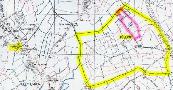
Kilcon is just half a mile from the center of the town of Mountnorris. See the Mountnorris Townland pages for a brief history and description of the area! |
|
|
|
This page is under construction! Information to be added:
|
|
Your help is needed. If you have anything that you think will add to this website, including records, that will help others when researching this townland's genealogy, please email me. |
Back to the County Armagh Townlands website....
Back to the County Armagh website....

All info, pictures and page developed & submitted by Walt Sammis
©2001-2011 ConnorsGenealogy,
Ireland GenWeb
last updated
September 10, 2011